Os cookies.
Este site utiliza cookies para lhe proporcionar uma melhor experiência de utilização.
OK, ACEITO
Sobre
Itens da coleção
Refinar a pesquisa
Coleções digitais
Biblioteca Geral
27
Mapas Nabais Conde
27
Tipo
Cartografia
27
Autor
Edgell, J. A.
7
Douglas, H. P.
4
Wharton, W. J. L.
4
Day, A.
3
Collins, K. St. B.
2
Ver mais
Data
1955
1954
1953
1951
1930
Ver mais
Local de publicação
Londres
27
Assunto
Mar Mediterrâneo
Mapa
27
Argélia
9
Tunísia
5
Egipto
4
Ver mais
Idioma
Inglês
PT
EN
PT
EN
Biblioteca de Fundo Antigo da UC
Almamater
Em destaque
Todos os itens
Sobre
Nesta coleção
Pesquisa avançada
Refinar a pesquisa
Limpar
Coleções digitais
Biblioteca Geral
27
Mapas Nabais Conde
27
Tipo
Cartografia
27
Autor
Edgell, J. A.
7
Douglas, H. P.
4
Wharton, W. J. L.
4
Day, A.
3
Collins, K. St. B.
2
Ver mais
Data
1955
1954
1953
1951
1930
Ver mais
Local de publicação
Londres
27
Assunto
Mar Mediterrâneo
Mapa
27
Argélia
9
Tunísia
5
Egipto
4
Ver mais
Idioma
Inglês
Itens
27
Ver como
Galeria
Lista
Grelha
Ordenar por
Título
Título (descendente)
Data (de publicação)
Data (descendente)
Limite por página
50
100
250
Cartografia
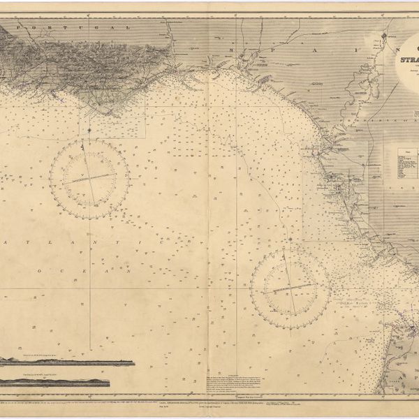
Cape St. Vincent to the Strait of Gibraltar : compiled from the latest government charts
Cartografia
Mediterranean : Africa : C. Tres Forcas to C. Ivi : surveyed by Captain E. Mouchez of the french Navy 1870-73
Cartografia
Mediterranean : Algeria : Algiers to C. Bougaroni : surveyed by Captain E. Mouchez of the french Navy 1867-9 : with corrections from the french gouvernment charts 1925-1926
Cartografia
Mediterranean : Algeria : Ports d'Oran and Mers-el-Kébir : from the french government chart of 1876 : with corrections to 1953
Cartografia
Mediterranean : Algeria : Tunis : C. Bougaroni to Fratelli Rocks including Galita Channel
Cartografia
Mediterranean : Algeric : approaches to Bone : from french government chart 1889 : with corrections from the french government chart 1929
Cartografia
Mediterranean : Algérie : C. Ivi to Alger : from the french government charts of 1867-1870 : with additions and corrections to 1951
Cartografia
Mediterranean : Coast of Palestine : Tyre to El Arish
Cartografia
Mediterranean : Gibraltar : surveyed by Capt. R. M. Southern R. N. and officers of H. M. Surveying ship "Challenger" : 1947-1948
Cartografia
Mediterranean : Israel : Bay of Acre ; Acre Anchorage ; Haifa Harbour
Cartografia
Mediterranean : Libya : Porto di Tripoli
Cartografia
Mediterranean : Tunisia : Baie de Tunis : from the french Gouvernment charts of 1893 : with corrections to 1953
Cartografia
Mediterranean : Tunisia : North Coast : Lac de Bizerte and Entrance : from french government charts to 1948 : with corrections to 1957
Cartografia
Mediterranean Sea : Algérie : C. Ferrat to C. Bougaroni : from the french government surveys of 1868-74 : the coast of Spain from spanish authorities
Cartografia
Mediterranean Sea : Algeria : approaches to Alger : from the french government charts to 1932 : with corrections to 1950
Cartografia
Mediterranean Sea : Algeria : Port d'Alger : from the french government chart of 1911 : with corrections to 1938
Cartografia
Mediterranean Sea : Egypt : Alexandria Harbour
Cartografia
Mediterranean Sea : Egypt : Alexandria to Port Saïd
Cartografia
Mediterranean Sea : Egypt : approaches to Port Said ; Port Said
Cartografia
Mediterranean Sea : Egypt : Damietta to El Arish
Cartografia
Mediterranean Sea : Europe Gibraltar to Alicante : Africa Cape Spartel to Cape Ferrat : from spanish and french government charts to 1877
Cartografia
Mediterranean Sea : Libya : Ras Ashdir to Sirte : from the italian Gouvernment charts of 1931-32
Cartografia
Mediterranean Sea : Marocco : Bahia de Ceuta : from the Spanish Gouvernment Chart of 1926 : with corrections to 1956
Cartografia
Mediterranean Sea : plans of the Coast of Libya : Rada and Porto di Tripoli : from the italian Gouvernment chart of 1930
Cartografia
Mediterranean Sea : Tunisia : East Coast : approaches to Sfax : from the french Gouvernment charts to 1952 : with corrections to 1953
Cartografia
Mediterranean Sea : Tunisia : East Coast : Kélibia to Tripoli : principally from french and italian Gouvernment charts to 1954
Cartografia
Strait of Gibraltar : from the spanish government charts of 1936 : with corrections to 1953