Os cookies.
Este site utiliza cookies para lhe proporcionar uma melhor experiência de utilização.
OK, ACEITO
Sobre
Itens da coleção
Refinar a pesquisa
Coleções digitais
Biblioteca Geral
17
Mapas Nabais Conde
17
Tipo
Cartografia
17
Autor
Day, A.
2
Day. A.
2
Edgell, J. A.
2
Estados Unidos da América. Central Intelligence Agency
2
Estados Unidos da América. Department of State
2
Ver mais
Data
1973
1972
1953
1951
1950
Ver mais
Local de publicação
Londres
10
Washington
6
Langley
1
Assunto
Mapa
9
Costa Ocidental
4
França
4
Mar Mediterrâneo
4
Gibraltar
2
Ver mais
Idioma
Inglês
PT
EN
PT
EN
Biblioteca de Fundo Antigo da UC
Almamater
Em destaque
Todos os itens
Sobre
Nesta coleção
Pesquisa avançada
Refinar a pesquisa
Limpar
Coleções digitais
Biblioteca Geral
17
Mapas Nabais Conde
17
Tipo
Cartografia
17
Autor
Day, A.
2
Day. A.
2
Edgell, J. A.
2
Estados Unidos da América. Central Intelligence Agency
2
Estados Unidos da América. Department of State
2
Ver mais
Data
1973
1972
1953
1951
1950
Ver mais
Local de publicação
Londres
10
Washington
6
Langley
1
Assunto
Mapa
9
Costa Ocidental
4
França
4
Mar Mediterrâneo
4
Gibraltar
2
Ver mais
Idioma
Inglês
Itens
17
Ver como
Grelha
Lista
Galeria
Ordenar por
Título
Título (descendente)
Data (de publicação)
Data (descendente)
Limite por página
50
100
250
Cartografia
Angola : background notes
United States. Department of State. Bureau of African Affairs
Cartografia
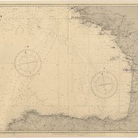
Bay of Biscay : from the latest information in the hydrographic Dept. to 1953
Day, A.
Cartografia
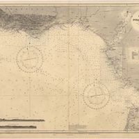
Cape St. Vincent to the Strait of Gibraltar : compiled from the latest government charts
Mostyn, A.
Cartografia
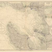
France : West Coast : Pertuis d'Antioche with the approaches to La Rochelle and Rochefort : from the latest french government charts to 1950 : with additions and corrections to 1953
Day. A.
Cartografia
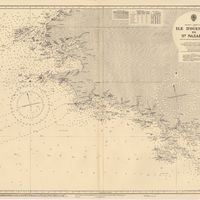
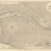
France West Coast : Ile d'Ouessant to St. Nazaire : from the French Government Charts to 1939
Edgell, John
Cartografia
France West Coast : La Loire St. Nazaire to Nantes : from French Government Charts to 1948 : with corrections to 1948
Day. A.
Cartografia
France West Coast Sheet V : Bourgneuf to I. de Groix : from the Pilote Francais with corrections from French Government Charts to 1949
Washington, Capitão
Cartografia
Iceland
Estados Unidos da América. Central Intelligence Agency
Cartografia
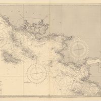
Mediterranean : Algeria : Ports d'Oran and Mers-el-Kébir : from the french government chart of 1876 : with corrections to 1953
Edgell, J. A.
Cartografia
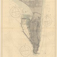
Mediterranean : Gibraltar : surveyed by Capt. R. M. Southern R. N. and officers of H. M. Surveying ship "Challenger" : 1947-1948
Day, A.
Cartografia
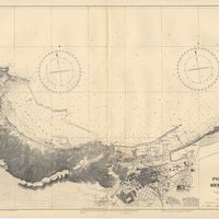
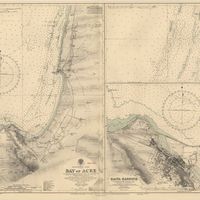
Mediterranean : Israel : Bay of Acre ; Acre Anchorage ; Haifa Harbour
Douglas, H. P.; Edgell, J. A.
Cartografia
Mozambique (Portugal)
Cartografia
Mozambique : background notes
United States. Department of State. Bureau of African Affairs
Cartografia
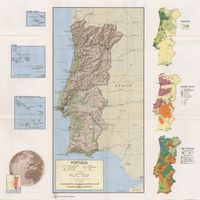
Portugal
Estados Unidos da América. Central Intelligence Agency
Cartografia
Portugal : background notes
Estados Unidos da América. Department of State
Cartografia
Portugal : West Coast : entrance of the River Tagus with the Harbour of Lisbon (Lisboa) : compiled from various Portuguese Government surveys to 1879 : with corrections to 1945
Richards, G. H.
Cartografia
Spain : background notes
Estados Unidos da América. Department of State