Os cookies.
Este site utiliza cookies para lhe proporcionar uma melhor experiência de utilização.
OK, ACEITO
Sobre
Itens da coleção
Refinar a pesquisa
Coleções digitais
Biblioteca Geral
8
Mapas Nabais Conde
8
Tipo
Cartografia
8
Autor
Edgell, J. A.
2
Wharton, W. J. L.
2
Day, Archibald
1
Parry, J. F.
1
Purey-Cust, H. E.
1
Ver mais
Data
1954
1939
1937
1936
1933
Ver mais
Local de publicação
Londres
Assunto
Mar Mediterrâneo
Mapa
8
Argélia
4
Líbia
2
Egipto
1
Ver mais
Idioma
Inglês
8
PT
EN
PT
EN
Biblioteca de Fundo Antigo da UC
Almamater
Em destaque
Todos os itens
Sobre
Nesta coleção
Pesquisa avançada
Refinar a pesquisa
Limpar
Coleções digitais
Biblioteca Geral
8
Mapas Nabais Conde
8
Tipo
Cartografia
8
Autor
Edgell, J. A.
2
Wharton, W. J. L.
2
Day, Archibald
1
Parry, J. F.
1
Purey-Cust, H. E.
1
Ver mais
Data
1954
1939
1937
1936
1933
Ver mais
Local de publicação
Londres
Assunto
Mar Mediterrâneo
Mapa
8
Argélia
4
Líbia
2
Egipto
1
Ver mais
Idioma
Inglês
8
Itens
8
Ver como
Grelha
Lista
Galeria
Ordenar por
Título
Título (descendente)
Data (de publicação)
Data (descendente)
Limite por página
50
100
250
Cartografia
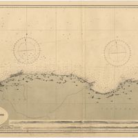
Mediterranean : Algeria : Algiers to C. Bougaroni : surveyed by Captain E. Mouchez of the french Navy 1867-9 : with corrections from the french gouvernment charts 1925-1926
Wharton, W. J. L.
Cartografia
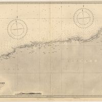
Mediterranean : Algérie : C. Ivi to Alger : from the french government charts of 1867-1870 : with additions and corrections to 1951
Wharton, W. J. L.
Cartografia
Mediterranean : Coast of Palestine : Tyre to El Arish
Edgell, J. A.
Cartografia
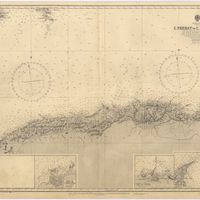
Mediterranean Sea : Algérie : C. Ferrat to C. Bougaroni : from the french government surveys of 1868-74 : the coast of Spain from spanish authorities
Richards, G. H.
Cartografia
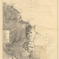
Mediterranean Sea : Algeria : Port d'Alger : from the french government chart of 1911 : with corrections to 1938
Purey-Cust, H. E.
Cartografia
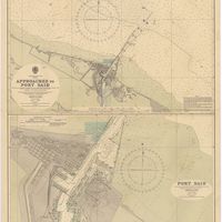
Mediterranean Sea : Egypt : approaches to Port Said ; Port Said
Day, Archibald
Cartografia
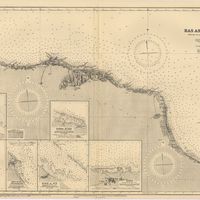
Mediterranean Sea : Libya : Ras Ashdir to Sirte : from the italian Gouvernment charts of 1931-32
Edgell, J. A.
Cartografia
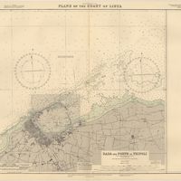
Mediterranean Sea : plans of the Coast of Libya : Rada and Porto di Tripoli : from the italian Gouvernment chart of 1930
Parry, J. F.