Os cookies.
Este site utiliza cookies para lhe proporcionar uma melhor experiência de utilização.
OK, ACEITO
Sobre
Itens da coleção
Refinar a pesquisa
Coleções digitais
Biblioteca Geral
37
Mapas Nabais Conde
37
Faculdade de Letras
1
Tipo
Cartografia
Autor
Wharton, W. J. L.
6
Day, A.
4
Edgell, J. A.
4
Chias y Carbó, Benito
3
Douglas, H. P.
3
Ver mais
Data
1955
1954
1953
1950
1925
4
Ver mais
Local de publicação
Londres
30
Barcelona
3
Lisboa
3
Gotha
1
Assunto
Mapa
28
Mar Mediterrâneo
17
Costa Ocidental
7
França
7
Argélia
6
Ver mais
Idioma
Inglês
30
Português
3
Espanhol
3
Alemão
1
PT
EN
PT
EN
Biblioteca de Fundo Antigo da UC
Almamater
Em destaque
Todos os itens
Sobre
Nesta coleção
Pesquisa avançada
Refinar a pesquisa
Limpar
Coleções digitais
Biblioteca Geral
37
Mapas Nabais Conde
37
Faculdade de Letras
1
Tipo
Cartografia
Autor
Wharton, W. J. L.
6
Day, A.
4
Edgell, J. A.
4
Chias y Carbó, Benito
3
Douglas, H. P.
3
Ver mais
Data
1955
1954
1953
1950
1925
4
Ver mais
Local de publicação
Londres
30
Barcelona
3
Lisboa
3
Gotha
1
Assunto
Mapa
28
Mar Mediterrâneo
17
Costa Ocidental
7
França
7
Argélia
6
Ver mais
Idioma
Inglês
30
Português
3
Espanhol
3
Alemão
1
Itens
37
Ver como
Grelha
Lista
Galeria
Ordenar por
Título
Título (descendente)
Data (de publicação)
Data (descendente)
Limite por página
50
100
250
Cartografia
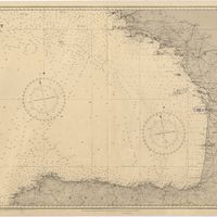
Bay of Biscay : from the latest information in the hydrographic Dept. to 1953
Day, A.
Cartografia
Beira Alta
Chias y Carbó, Benito; Ribera, Joaquim
Cartografia
Beira Baixa
Chias y Carbó, Benito
Cartografia
Cape St. Vincent to the Strait of Gibraltar : compiled from the latest government charts
Mostyn, A.
Cartografia
Carta das estradas de Portugal na escala 1:200 000
Teixeira, C.
Cartografia
Carta geológica de Portugal
Portugal. Direcção Geral de Minas e Serviços Geológicos. Serviços Geológicos
Cartografia
Douro
Chias y Carbó, Benito
Cartografia
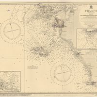
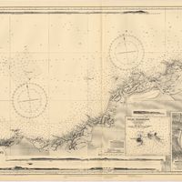
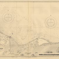
France : West Coast : Entrance to La Gironde : from the french government charts of 1887 : with additions and corrections to 1955
Wharton, W. J. L.
Cartografia
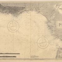
France : West Coast : Pertuis d'Antioche with the approaches to La Rochelle and Rochefort : from the latest french government charts to 1950 : with additions and corrections to 1953
Day. A.
Cartografia
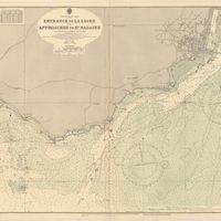
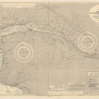
France West Coast : entrance to La Loire and approaches to St. Nazaire : from the French Government Charts of 1893 : with corrections to 1954
Wharton, W. J. L.
Cartografia
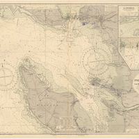
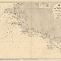
France West Coast : Ile d'Ouessant to St. Nazaire : from the French Government Charts to 1939
Edgell, John
Cartografia
France West Coast : La Loire St. Nazaire to Nantes : from French Government Charts to 1948 : with corrections to 1948
Day. A.
Cartografia
France West Coast Sheet IV : Les Sables d'Olonne to Bourgneuf : from the Pilote Francais with corrections from French Government Charts to 1924
Washington, Capitão
Cartografia
France West Coast Sheet V : Bourgneuf to I. de Groix : from the Pilote Francais with corrections from French Government Charts to 1949
Washington, Capitão
Cartografia
Mapa de Portugal Ilhas e Colónias
Silva, J. R.
Cartografia
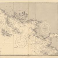
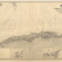
Mediterranean : Africa : C. Tres Forcas to C. Ivi : surveyed by Captain E. Mouchez of the french Navy 1870-73
Wharton, W. J. L.
Cartografia
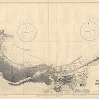
Mediterranean : Algeria : Ports d'Oran and Mers-el-Kébir : from the french government chart of 1876 : with corrections to 1953
Edgell, J. A.
Cartografia
Mediterranean : Algeric : approaches to Bone : from french government chart 1889 : with corrections from the french government chart 1929
Wharton, W. J. L.
Cartografia
Mediterranean : Algérie : C. Ivi to Alger : from the french government charts of 1867-1870 : with additions and corrections to 1951
Wharton, W. J. L.
Cartografia
Mediterranean : Gibraltar : surveyed by Capt. R. M. Southern R. N. and officers of H. M. Surveying ship "Challenger" : 1947-1948
Day, A.
Cartografia
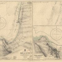
Mediterranean : Israel : Bay of Acre ; Acre Anchorage ; Haifa Harbour
Douglas, H. P.; Edgell, J. A.
Cartografia
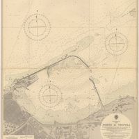
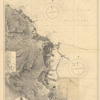
Mediterranean : Libya : Porto di Tripoli
Wyatt, Guy
Cartografia
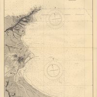
Mediterranean : Tunisia : Baie de Tunis : from the french Gouvernment charts of 1893 : with corrections to 1953
Day, A.
Cartografia
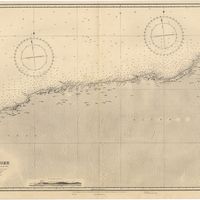
Mediterranean Sea : Algérie : C. Ferrat to C. Bougaroni : from the french government surveys of 1868-74 : the coast of Spain from spanish authorities
Richards, G. H.
Cartografia
Mediterranean Sea : Algeria : Port d'Alger : from the french government chart of 1911 : with corrections to 1938
Purey-Cust, H. E.
Cartografia
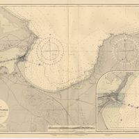
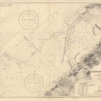
Mediterranean Sea : Egypt : Alexandria Harbour
Hardy, N. A. C.; Day, A.; Edgell, J. A.
Cartografia
Mediterranean Sea : Egypt : Alexandria to Port Saïd
Reyne, F. A.; Hill, S. A. G.; Douglas, H. P.
Cartografia
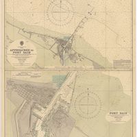
Mediterranean Sea : Egypt : approaches to Port Said ; Port Said
Day, Archibald
Cartografia
Mediterranean Sea : Egypt : Damietta to El Arish
Douglas, H. P.
Cartografia
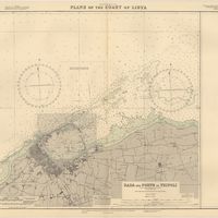
Mediterranean Sea : plans of the Coast of Libya : Rada and Porto di Tripoli : from the italian Gouvernment chart of 1930
Parry, J. F.
Cartografia
Portsmouth to Canary Islands (Islas Canarias) and the Azores (Açôres) : compiled from the latest information in the hydrographic Department, 1954
Wyatt, A. G. N.
Cartografia
Portugal
Justus Perthes (Firma)
Cartografia
Portugal : Berlenga to Cabo Espichel including the approaches to Rio Tejo : compiled from portuguese government charts to 1935 : with additions and corrections to 1956
Wharton, W. J. L.
Cartografia
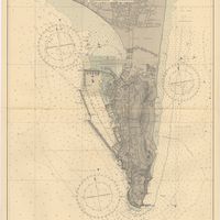
Portugal : West Coast : entrance of the River Tagus with the Harbour of Lisbon (Lisboa) : compiled from various Portuguese Government surveys to 1879 : with corrections to 1945
Richards, G. H.
Cartografia
Spain : South Coast : Pta. del Acebuche to Pta. de la Chullera including Gibraltar Bay : from the spanish government charts of 1872-1914
Mostyn, A.
Cartografia
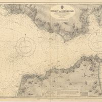
Strait of Gibraltar : from the spanish government charts of 1936 : with corrections to 1953
Edgell, J. A.
Cartografia
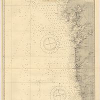
West coasts of Spain and Portugal : Cabo Villanno to Oporto : from the spanish and portuguese government charts to 1916 : with corrections and additions to 1921
Learmonth, Frederick C.