Os cookies.
Este site utiliza cookies para lhe proporcionar uma melhor experiência de utilização.
OK, ACEITO
Sobre
Itens da coleção
Refinar a pesquisa
Coleções digitais
Biblioteca Geral
22
Mapas Nabais Conde
22
Tipo
Cartografia
Autor
Edgell, J. A.
4
Washington, Capitão
4
Wharton, W. J. L.
4
Douglas, H. P.
3
Edgell, John
3
Ver mais
Data
1951
1935
1930
1919
1910
Ver mais
Local de publicação
Londres
Assunto
Mapa
Mar Mediterrâneo
13
França
8
Costa Ocidental
7
Argélia
6
Ver mais
Idioma
Inglês
22
PT
EN
PT
EN
Biblioteca de Fundo Antigo da UC
Almamater
Em destaque
Todos os itens
Sobre
Nesta coleção
Pesquisa avançada
Refinar a pesquisa
Limpar
Coleções digitais
Biblioteca Geral
22
Mapas Nabais Conde
22
Tipo
Cartografia
Autor
Edgell, J. A.
4
Washington, Capitão
4
Wharton, W. J. L.
4
Douglas, H. P.
3
Edgell, John
3
Ver mais
Data
1951
1935
1930
1919
1910
Ver mais
Local de publicação
Londres
Assunto
Mapa
Mar Mediterrâneo
13
França
8
Costa Ocidental
7
Argélia
6
Ver mais
Idioma
Inglês
22
Itens
22
Ver como
Grelha
Lista
Galeria
Ordenar por
Título
Título (descendente)
Data (de publicação)
Data (descendente)
Limite por página
50
100
250
Cartografia
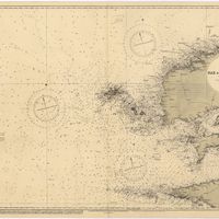
Cape St. Vincent to the Strait of Gibraltar : compiled from the latest government charts
Mostyn, A.
Cartografia
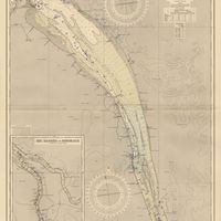
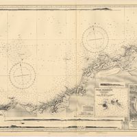
France : West Coast : La Gironde Royan to Bordeaux : from the french government chart of 1914 : with additions and corrections to 1954
Day, Archibald
Cartografia
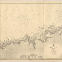
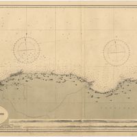
France North Coast : Sheet VIII : Ushant to Plateau des Roches Douvres : from the pilote français 1823 : with additions and corrections to 1911
Wharton, W. J. L.
Cartografia
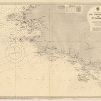
France West Coast : Ile d'Ouessant to St. Nazaire : from the French Government Charts to 1939
Edgell, John
Cartografia
France West Coast Sheet III : Pte. de la Coubre to les Sables d'Olonne : from the French Government Charts to 1940
Edgell, John
Cartografia
France West Coast Sheet IV : Les Sables d'Olonne to Bourgneuf : from the Pilote Francais with corrections from French Government Charts to 1924
Washington, Capitão
Cartografia
France West Coast Sheet V : Bourgneuf to I. de Groix : from the Pilote Francais with corrections from French Government Charts to 1949
Washington, Capitão
Cartografia
France West Coast Sheet VI : I. de Groix to Raz de Sein : from the French Government Charts of 1828 : with corrections to 1933
Washington, Capitão
Cartografia
France-North West Coast : Sheet VII : Raz de Sein to Goulven including Brest and Ushant : from French Government Charts to 1919
Washington, Capitão
Cartografia
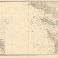
Mediterranean : Africa : C. Tres Forcas to C. Ivi : surveyed by Captain E. Mouchez of the french Navy 1870-73
Wharton, W. J. L.
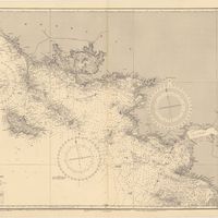
Cartografia
Mediterranean : Algeria : Algiers to C. Bougaroni : surveyed by Captain E. Mouchez of the french Navy 1867-9 : with corrections from the french gouvernment charts 1925-1926
Wharton, W. J. L.
Cartografia
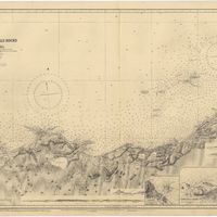
Mediterranean : Algeria : Tunis : C. Bougaroni to Fratelli Rocks including Galita Channel
Richards, G. H.
Cartografia
Mediterranean : Algeric : approaches to Bone : from french government chart 1889 : with corrections from the french government chart 1929
Wharton, W. J. L.
Cartografia
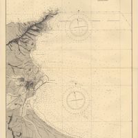
Mediterranean : Coast of Palestine : Tyre to El Arish
Edgell, J. A.
Cartografia
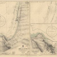
Mediterranean : Israel : Bay of Acre ; Acre Anchorage ; Haifa Harbour
Douglas, H. P.; Edgell, J. A.
Cartografia
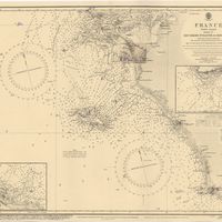
Mediterranean Sea : Algeria : approaches to Alger : from the french government charts to 1932 : with corrections to 1950
Edgell, John
Cartografia
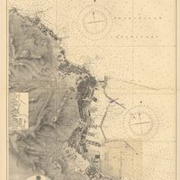
Mediterranean Sea : Algeria : Port d'Alger : from the french government chart of 1911 : with corrections to 1938
Purey-Cust, H. E.
Cartografia
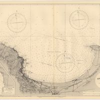
Mediterranean Sea : Egypt : Alexandria to Port Saïd
Reyne, F. A.; Hill, S. A. G.; Douglas, H. P.
Cartografia
Mediterranean Sea : Egypt : Damietta to El Arish
Douglas, H. P.
Cartografia
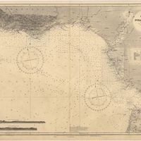
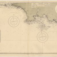
Mediterranean Sea : Europe Gibraltar to Alicante : Africa Cape Spartel to Cape Ferrat : from spanish and french government charts to 1877
Evans, F. J.
Cartografia
Mediterranean Sea : Libya : Ras Ashdir to Sirte : from the italian Gouvernment charts of 1931-32
Edgell, J. A.
Cartografia
Spain : North Coast : Foz to Camariñas : from the spanish government charts of 1915 to 1920 : with additions and corrections to 1935
Edgell, J. A.