Os cookies.
Este site utiliza cookies para lhe proporcionar uma melhor experiência de utilização.
OK, ACEITO
Sobre
Itens da coleção
Refinar a pesquisa
Coleções digitais
Biblioteca Geral
9
Mapas Nabais Conde
9
Tipo
Cartografia
9
Autor
Bedford, George Augustus
6
Vidal, Alexander Thomas Emeric
6
Walker, J. & C.
6
Owen, William Fitzwilliam
2
Allen, William
1
Ver mais
Data
1842
1841
1810
1772
1755
Ver mais
Local de publicação
Londres
Assunto
Carta náutica
Oceano Atlântico
8
África
6
Costa Ocidental
6
Açores
2
Ver mais
Idioma
Inglês
9
PT
EN
PT
EN
Biblioteca de Fundo Antigo da UC
Almamater
Em destaque
Todos os itens
Sobre
Nesta coleção
Pesquisa avançada
Refinar a pesquisa
Limpar
Coleções digitais
Biblioteca Geral
9
Mapas Nabais Conde
9
Tipo
Cartografia
9
Autor
Bedford, George Augustus
6
Vidal, Alexander Thomas Emeric
6
Walker, J. & C.
6
Owen, William Fitzwilliam
2
Allen, William
1
Ver mais
Data
1842
1841
1810
1772
1755
Ver mais
Local de publicação
Londres
Assunto
Carta náutica
Oceano Atlântico
8
África
6
Costa Ocidental
6
Açores
2
Ver mais
Idioma
Inglês
9
Itens
9
Ver como
Grelha
Lista
Galeria
Ordenar por
Título
Título (descendente)
Data (de publicação)
Data (descendente)
Limite por página
50
100
250
Cartografia
A Chart of the Açores (Hawks) Islands, called also Flemish and Western Islands from Mr. D'Anviille with several additions.
Cartografia
Chart of the Açores (Hawks) Islands, called also Flemish and Western Islands.
Cartografia
A topographical chart of the entrance of the river Tagus, describing the coast from Cape Roca to Sacavem ; with the harbour and environs of Lisbon. The nautical part is from a survey taken in 1806 by W. Chapman, Master of the Royal Navy; and approved by the Chart Committee of the Admiralty. The interior and line of the coast are drawn from survays made by officers of the Quarter Master General's Department
Chapman, William
Cartografia
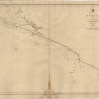
West Coast of Africa : Sheet IX : Sherboro Island to Cape Mesurada
Bedford, George Augustus; Vidal, Alexander Thomas Emeric
Cartografia
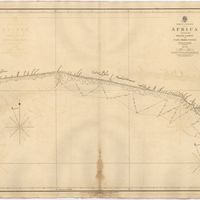
West Coast of Africa : Sheet XI : Cape Palmas to Grand Lahou
Vidal, Alexander Thomas Emeric; Bedford, George Augustus
Cartografia
West Coast of Africa : Sheet XII : Grand Lahou to Cape Three Points
Vidal, Alexander Thomas Emeric; Bedford, George Augustus
Cartografia
West Coast of Africa : Sheet XIV : Barracoe to Cape St. Paul
Vidal, Alexander Thomas Emeric; Bedford, George Augustus
Cartografia
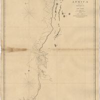
West Coast of Africa : Sheet XVII : Cape Formosa to Fernando Po
Owen, William Fitzwilliam; Bedford, George Augustus; Vidal, Alexander Thomas Emeric; Allen, William
Cartografia
West Coast of Africa : Sheet XVIII : Fernando Po to Cape Lopez
Owen, William Fitzwilliam; Bedford, George Augustus; Vidal, Alexander Thomas Emeric