Os cookies.
Este site utiliza cookies para lhe proporcionar uma melhor experiência de utilização.
OK, ACEITO
Sobre
Itens da coleção
Refinar a pesquisa
Coleções digitais
Mapas Nabais Conde
Biblioteca Geral
9
Tipo
Cartografia
9
Autor
Edgell, J. A.
3
Day, A.
2
Douglas, H. P.
2
Collins, K. St. B.
1
Hardy, N. A. C.
1
Ver mais
Data
1957
1956
1955
1951
1939
Ver mais
Local de publicação
Londres
Assunto
Mapa
Mar Mediterrâneo
Gibraltar
2
Tunísia
2
Alexandria
1
Ver mais
Idioma
Inglês
9
PT
EN
PT
EN
Biblioteca de Fundo Antigo da UC
Almamater
Em destaque
Todos os itens
Sobre
Nesta coleção
Pesquisa avançada
Refinar a pesquisa
Limpar
Coleções digitais
Mapas Nabais Conde
Biblioteca Geral
9
Tipo
Cartografia
9
Autor
Edgell, J. A.
3
Day, A.
2
Douglas, H. P.
2
Collins, K. St. B.
1
Hardy, N. A. C.
1
Ver mais
Data
1957
1956
1955
1951
1939
Ver mais
Local de publicação
Londres
Assunto
Mapa
Mar Mediterrâneo
Gibraltar
2
Tunísia
2
Alexandria
1
Ver mais
Idioma
Inglês
9
Itens
9
Ver como
Grelha
Lista
Galeria
Ordenar por
Título
Título (descendente)
Data (de publicação)
Data (descendente)
Limite por página
50
100
250
Cartografia
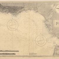
Cape St. Vincent to the Strait of Gibraltar : compiled from the latest government charts
Mostyn, A.
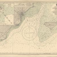
Cartografia
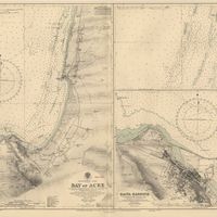
Mediterranean : Israel : Bay of Acre ; Acre Anchorage ; Haifa Harbour
Douglas, H. P.; Edgell, J. A.
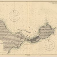
Cartografia
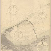
Mediterranean : Libya : Porto di Tripoli
Wyatt, Guy
Cartografia
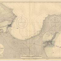
Mediterranean : Tunisia : Baie de Tunis : from the french Gouvernment charts of 1893 : with corrections to 1953
Day, A.
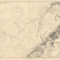
Cartografia
Mediterranean Sea : Algeria : Port d'Alger : from the french government chart of 1911 : with corrections to 1938
Purey-Cust, H. E.
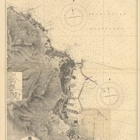
Cartografia
Mediterranean Sea : Egypt : Alexandria Harbour
Hardy, N. A. C.; Day, A.; Edgell, J. A.
Cartografia
Mediterranean Sea : Marocco : Bahia de Ceuta : from the Spanish Gouvernment Chart of 1926 : with corrections to 1956
Douglas, H. P.
Cartografia
Mediterranean Sea : Tunisia : East Coast : approaches to Sfax : from the french Gouvernment charts to 1952 : with corrections to 1953
Collins, K. St. B.
Cartografia
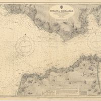
Strait of Gibraltar : from the spanish government charts of 1936 : with corrections to 1953
Edgell, J. A.