Os cookies.
Este site utiliza cookies para lhe proporcionar uma melhor experiência de utilização.
OK, ACEITO
Sobre
Itens da coleção
Refinar a pesquisa
Coleções digitais
Mapas Nabais Conde
Biblioteca Geral
11
Tipo
Cartografia
11
Autor
Edgell, J. A.
2
Richards, G. H.
2
Washington, Capitão
2
Collins, K. St. B.
1
Day, A.
1
Ver mais
Data
1958
1956
1950
1922
1904
Ver mais
Local de publicação
Londres
Assunto
Mapa
5
Oceano Atlântico
5
Costa
4
Espanha
4
Portugal
4
Ver mais
Idioma
Inglês
11
PT
EN
PT
EN
Biblioteca de Fundo Antigo da UC
Almamater
Em destaque
Todos os itens
Sobre
Nesta coleção
Pesquisa avançada
Refinar a pesquisa
Limpar
Coleções digitais
Mapas Nabais Conde
Biblioteca Geral
11
Tipo
Cartografia
11
Autor
Edgell, J. A.
2
Richards, G. H.
2
Washington, Capitão
2
Collins, K. St. B.
1
Day, A.
1
Ver mais
Data
1958
1956
1950
1922
1904
Ver mais
Local de publicação
Londres
Assunto
Mapa
5
Oceano Atlântico
5
Costa
4
Espanha
4
Portugal
4
Ver mais
Idioma
Inglês
11
Itens
11
Ver como
Grelha
Lista
Galeria
Ordenar por
Título
Título (descendente)
Data (de publicação)
Data (descendente)
Limite por página
50
100
250
Cartografia
France West Coast Sheet V : Bourgneuf to I. de Groix : from the Pilote Francais with corrections from French Government Charts to 1949
Washington, Capitão
Cartografia
France West Coast Sheet VI : I. de Groix to Raz de Sein : from the French Government Charts of 1828 : with corrections to 1933
Washington, Capitão
Cartografia
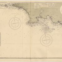
Mediterranean : Tunisia : North Coast : Lac de Bizerte and Entrance : from french government charts to 1948 : with corrections to 1957
Edgell, J. A.
Cartografia
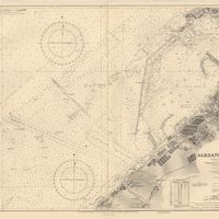
Mediterranean Sea : Egypt : Alexandria Harbour
Hardy, N. A. C.; Day, A.; Edgell, J. A.
Cartografia
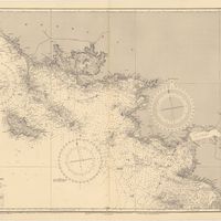
Mediterranean Sea : Tunisia : East Coast : Kélibia to Tripoli : principally from french and italian Gouvernment charts to 1954
Collins, K. St. B.
Cartografia
Portugal : Berlenga to Cabo Espichel including the approaches to Rio Tejo : compiled from portuguese government charts to 1935 : with additions and corrections to 1956
Wharton, W. J. L.
Cartografia
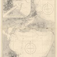
Portugal : West Coast : entrance of the River Tagus with the Harbour of Lisbon (Lisboa) : compiled from various Portuguese Government surveys to 1879 : with corrections to 1945
Richards, G. H.
Cartografia
Spain : West Coast : Ria de Vigo : from the spanish government chart of 1912
Parry, J. F.
Cartografia
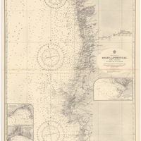
West coast of Spain and Portugal : Cabo Villano to Cabo de S.º Vicente : compiled from the latest information in the Hidrographic Office to 1958
Richards, G. H.
Cartografia
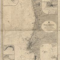
West coast of Spain and Portugal : Cape Finisterre to Cape St. Vincent : compiled from the latest information in the Hidrographic Office to 1881
Richards, George Henry
Cartografia
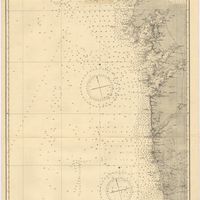
West coasts of Spain and Portugal : Cabo Villanno to Oporto : from the spanish and portuguese government charts to 1916 : with corrections and additions to 1921
Learmonth, Frederick C.