Os cookies.
Este site utiliza cookies para lhe proporcionar uma melhor experiência de utilização.
OK, ACEITO
Sobre
Itens da coleção
Refinar a pesquisa
Coleções digitais
Mapas Nabais Conde
Biblioteca Geral
8
EU
1
Tipo
Cartografia
Autor
Gibson, John
2
Jefferys, Thomas
1
Kitchen, Thomas
1
Parker, S.
1
Ralph, B.
1
Data
1762
1761
1758
1756
1755
Ver mais
Local de publicação
Londres
Assunto
Portugal
3
Lisboa
2
1758
1
Açores
1
Algarve
1
Ver mais
Idioma
Inglês
7
Português
1
PT
EN
PT
EN
Biblioteca de Fundo Antigo da UC
Almamater
Em destaque
Todos os itens
Sobre
Nesta coleção
Pesquisa avançada
Refinar a pesquisa
Limpar
Coleções digitais
Mapas Nabais Conde
Biblioteca Geral
8
EU
1
Tipo
Cartografia
Autor
Gibson, John
2
Jefferys, Thomas
1
Kitchen, Thomas
1
Parker, S.
1
Ralph, B.
1
Data
1762
1761
1758
1756
1755
Ver mais
Local de publicação
Londres
Assunto
Portugal
3
Lisboa
2
1758
1
Açores
1
Algarve
1
Ver mais
Idioma
Inglês
7
Português
1
Itens
8
Ver como
Grelha
Lista
Galeria
Ordenar por
Título
Título (descendente)
Data (de publicação)
Data (descendente)
Limite por página
50
100
250
Cartografia
A Chart of the Açores (Hawks) Islands, called also Flemish and Western Islands from Mr. D'Anviille with several additions.
Cartografia
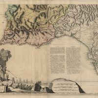
A chart of the sea coasts of Algrave [sic] and Andalusia between cape St. Vincent and the strait of Gibralter and c. Spartel
Cartografia
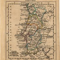
A map of the Kingdom of Portugal
Cartografia
A Map of the River Tale to Lisbon Done from a New Survey
Cartografia
Mappa ou carta geographica dos reinos de Portugal e Algarve
Jefferys, Thomas; Ralph, B.
Cartografia
A plan of the city of Lisbon with the Harbour, Forts, Depth of Water and Country adjacent : for the Lond. Mag.
Cartografia
Portugal
Cartografia
Spain and Portugal. A map of the mouth of the River Tagus or harbour of the city of Lisbon