Os cookies.
Este site utiliza cookies para lhe proporcionar uma melhor experiência de utilização.
OK, ACEITO
Sobre
Itens da coleção
Refinar a pesquisa
Coleções digitais
Biblioteca Geral
Mapas Nabais Conde
27
História da Ciência
1
OG
1
Tipo
Cartografia
Autor
Bellin, Jacques Nicolas
5
Gibson, John
2
Alagna, J. Giacomo
1
Crepy
1
Florez, Enrique
1
Ver mais
Data
1775
1770
1764
1760
1756
Ver mais
Local de publicação
Londres
12
Paris
6
Veneza
3
Amesterdão
1
Augsburgo
1
Ver mais
Assunto
Mapa
11
Portugal
6
Açores
5
Lisboa
3
Peninsula Ibérica
3
Ver mais
Idioma
Inglês
12
Francês
9
Italiano
3
Latim
3
Português
1
PT
EN
PT
EN
Biblioteca de Fundo Antigo da UC
Almamater
Em destaque
Todos os itens
Sobre
Nesta coleção
Pesquisa avançada
Refinar a pesquisa
Limpar
Coleções digitais
Biblioteca Geral
Mapas Nabais Conde
27
História da Ciência
1
OG
1
Tipo
Cartografia
Autor
Bellin, Jacques Nicolas
5
Gibson, John
2
Alagna, J. Giacomo
1
Crepy
1
Florez, Enrique
1
Ver mais
Data
1775
1770
1764
1760
1756
Ver mais
Local de publicação
Londres
12
Paris
6
Veneza
3
Amesterdão
1
Augsburgo
1
Ver mais
Assunto
Mapa
11
Portugal
6
Açores
5
Lisboa
3
Peninsula Ibérica
3
Ver mais
Idioma
Inglês
12
Francês
9
Italiano
3
Latim
3
Português
1
Itens
28
Ver como
Grelha
Lista
Galeria
Ordenar por
Título
Título (descendente)
Data (de publicação)
Data (descendente)
Limite por página
50
100
250
Cartografia
Carta geographica da America Portugueza ou terreno americano
Sousa, Tomás de
Cartografia
Carte de l?Espagne Ancienne : divisée par Auguste en Citérieure et Ultérieure...
Tour, Louis Brion de la
Cartografia
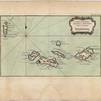
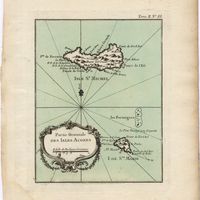
Carte des Isles Açores ou Terceres : partie occidentale
Bellin, Jacques Nicolas
Cartografia
Carte des Isles de Madere et Portosanto : Dressée sur les Journaux des plus habiles Navigateurs
Schley, Jakob van der
Cartografia
Carte des Royaumes d'Espagne et de Portugal : dans laquelle sont tracées les Routes des Postes
Robert de Vaugondy, Gilles
Cartografia
Chart of the Açores (Hawks) Islands, called also Flemish and Western Islands.
Cartografia
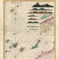
A Chart of the Maderas and Canary Islands : from the Draughts and Memoirs of Captn. George Glas : Regulated and Ascertained by Astronomical Observations.
Cartografia
A chart of the sea coasts of Algrave [sic] and Andalusia between cape St. Vincent and the strait of Gibralter and c. Spartel
Cartografia
L'Estremadura di Portogallo Alentejo ed Algarve di Nuova Projezione
Cartografia
Lvsitania ptolemaei
Florez, Enrique
Cartografia
A Map of the River Tale to Lisbon Done from a New Survey
Cartografia
Il mappamondo o sia descrizione generale del globo, ridotto in quadro
Cartografia
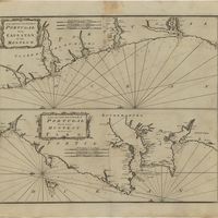
A new and correct chart of the coast of Portugal from Cape Stan to Cape Montego ; A new and correct chart of the coast of Portugal from Cape Montego to Pont de Faro
Cartografia
Partie Orientale des Isles Açores
Bellin, Jacques Nicolas
Cartografia
Plan du port de Lisbonne
Bellin, Jacques Nicolas
Cartografia
Plan du port de Lisbonne et des costes voisines Echelle de troid lieues marines de France de Vingt ou Deg.
Bellin, Jacques Nicolas
Cartografia
A plan of the city of Lisbon with the Harbour, Forts, Depth of Water and Country adjacent : for the Lond. Mag.
Cartografia
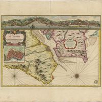
Port et Ville d'Angra dans l'Isle de Tercere
Bellin, Jacques Nicolas
Cartografia
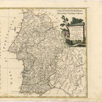
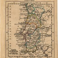
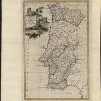
Portugal
Cartografia
Portugalliae et Algarbiae Regna : Cui confin: Hispan:Prov:simud vero pecul:Mappa BRASILLIAE REGN:in America Meri:cujus oramarit:Reg:Portu:Domin:veneratur et Primog:Regio Infanti prope dicata florett, recentina delineat Cura et Studio M. Seutter S.CMG: Aug. V
Seutter, George Matthaus
Cartografia
Regno di Portogallo
Cartografia
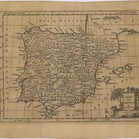
Regnorum Hispaniae et Portugalliae : tabula generalis
Homann, Johann Baptist
Cartografia
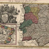
Royaume de Portugal
Crepy
Cartografia
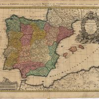
Spain and Portugal
Kitchin, Thomas,
Cartografia
Spain and Portugal. A map of the mouth of the River Tagus or harbour of the city of Lisbon
Cartografia
The theatre of war in Portugal with the distances of the fortified towns, from Lisbon
Cartografia
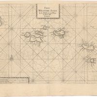
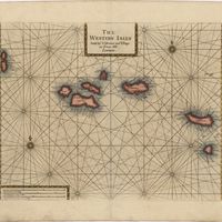
The Western Isles
Cartografia
The Western Isles