Os cookies.
Este site utiliza cookies para lhe proporcionar uma melhor experiência de utilização.
OK, ACEITO
Sobre
Itens da coleção
Refinar a pesquisa
Coleções digitais
Biblioteca Geral
Mapas Nabais Conde
Tipo
Cartografia
14
Gravuras e Desenhos
1
Autor
Elliott, Wm, Capt.
3
Neele, Samuel John
3
López de Vargas Machuca, Tomás
2
Nantiat, Jasper
2
Arrowsmith, Aaron
1
Ver mais
Data
1810
1809
1808
Ver mais
Local de publicação
Londres
11
Friburgo em Brisgóvia
1
Paris
1
Assunto
Mapa
8
Portugal
6
Invasões francesas
3
Peninsula Ibérica
3
Carta militar
2
Ver mais
Idioma
Inglês
10
Francês
1
Alemão
1
Português
1
Espanhol
1
PT
EN
PT
EN
Biblioteca de Fundo Antigo da UC
Almamater
Em destaque
Todos os itens
Sobre
Nesta coleção
Pesquisa avançada
Refinar a pesquisa
Limpar
Coleções digitais
Biblioteca Geral
Mapas Nabais Conde
Tipo
Cartografia
14
Gravuras e Desenhos
1
Autor
Elliott, Wm, Capt.
3
Neele, Samuel John
3
López de Vargas Machuca, Tomás
2
Nantiat, Jasper
2
Arrowsmith, Aaron
1
Ver mais
Data
1810
1809
1808
Ver mais
Local de publicação
Londres
11
Friburgo em Brisgóvia
1
Paris
1
Assunto
Mapa
8
Portugal
6
Invasões francesas
3
Peninsula Ibérica
3
Carta militar
2
Ver mais
Idioma
Inglês
10
Francês
1
Alemão
1
Português
1
Espanhol
1
Itens
15
Ver como
Grelha
Lista
Galeria
Ordenar por
Título
Título (descendente)
Data (de publicação)
Data (descendente)
Limite por página
50
100
250
Cartografia
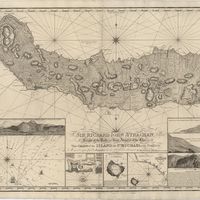
Chart of the Island of St. Michael
Read, W. Harding
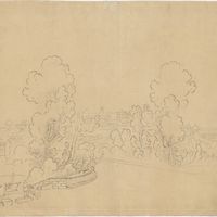
Gravuras e Desenhos
[Entrance to Coimbra].
Cartografia
Mapa de España y Portugal
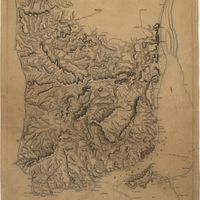
Cartografia
A Military sketch of the country between Lisbon and Vimiero occupied by the British Army under the command of Lieutenant General Viscount Wellington
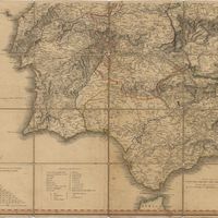
Cartografia
A new map of Spain and Portugal : exhibiting the chains of mountains with their passes, the principal & cross roads, with other details requisite for the intelligence of Military Operations
Nantiat, Jasper
Cartografia
A new map of Spain and Portugal : exhibiting the chains of mountains with their passes, the principal & cross roads, with other details requisite for the intelligence of Military Operations
Nantiat, Jasper
Cartografia
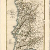
A new military map of Portugal : the roads from the Carta Militar published by the french in Lisbon : the rivers and mountains from the last Authorities
Elliott, Wm, Capt.
Cartografia
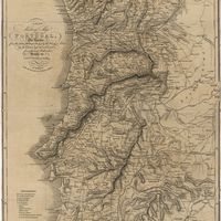
A new military map of Portugal : the roads from the Carta Militar published by the french in Lisbon : the rivers and mountains from the last Authorities
Elliott, Wm, Capt.
Cartografia
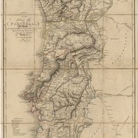
A new military map of Portugal : the roads from the Carta militar published by the french in Lisbon, the rivers and montains, from the best authorities
Elliott, Wm, Capt.
Cartografia
Plan du siége d'Almeida par l'Armée Française en 1810
Cartografia
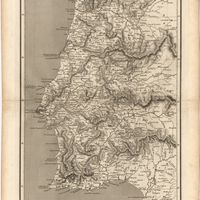
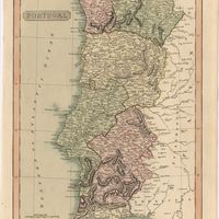
Portugal
Arrowsmith, Aaron
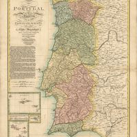
Cartografia
Portugal
Cartografia
Portugal including Algarve
Tofinõ de San Miguel, Vicente; López de Vargas Machuca, Tomás
Cartografia
Schlachten der neurn Zeit 155.tes Blatt : Schlacht bei OṔorto den 29ten. März 1809 = Batailles de L'Age Moderne 155me. feuille : Bataille d'O'Porto de 29 mars 1809.
Cartografia
A topographical chart of the entrance of the river Tagus, describing the coast from Cape Roca to Sacavem ; with the harbour and environs of Lisbon. The nautical part is from a survey taken in 1806 by W. Chapman, Master of the Royal Navy; and approved by the Chart Committee of the Admiralty. The interior and line of the coast are drawn from survays made by officers of the Quarter Master General's Department
Chapman, William