Os cookies.
Este site utiliza cookies para lhe proporcionar uma melhor experiência de utilização.
OK, ACEITO
Sobre
Itens da coleção
Refinar a pesquisa
Coleções digitais
Biblioteca Geral
143
Mapas Nabais Conde
141
Botânica
38
500 Anos da Biblioteca
1
EU
1
Tipo
Cartografia
131
Manuscrito
36
Gravuras e Desenhos
10
Livro Antigo
2
Livro Moderno
1
Ver mais
Autor
Thiselton-Dyer, William Turner
18
Walker, J. & C.
17
Vidal, Alexander Thomas Emeric
11
Owen, William Fitzwilliam
10
Edgell, J. A.
8
Ver mais
Data
1954-1955
11
1922-1934
11
1868-1877
11
1842-1865
10
1626-1747
12
Ver mais
Local de publicação
Londres
Kew
2
Nova Iorque
2
Dublin
1
Edimburgo
1
Assunto
Mapa
73
Portugal
35
Mar Mediterrâneo
28
Costa Ocidental
23
Oceano Atlântico
23
Ver mais
Idioma
Inglês
PT
EN
PT
EN
Biblioteca de Fundo Antigo da UC
Almamater
Em destaque
Todos os itens
Sobre
Nesta coleção
Pesquisa avançada
Refinar a pesquisa
Limpar
Coleções digitais
Biblioteca Geral
143
Mapas Nabais Conde
141
Botânica
38
500 Anos da Biblioteca
1
EU
1
Tipo
Cartografia
131
Manuscrito
36
Gravuras e Desenhos
10
Livro Antigo
2
Livro Moderno
1
Ver mais
Autor
Thiselton-Dyer, William Turner
18
Walker, J. & C.
17
Vidal, Alexander Thomas Emeric
11
Owen, William Fitzwilliam
10
Edgell, J. A.
8
Ver mais
Data
1954-1955
11
1922-1934
11
1868-1877
11
1842-1865
10
1626-1747
12
Ver mais
Local de publicação
Londres
Kew
2
Nova Iorque
2
Dublin
1
Edimburgo
1
Assunto
Mapa
73
Portugal
35
Mar Mediterrâneo
28
Costa Ocidental
23
Oceano Atlântico
23
Ver mais
Idioma
Inglês
Itens
181
Ver como
Galeria
Lista
Grelha
Ordenar por
Título
Título (descendente)
Data (de publicação)
Data (descendente)
Páginas
1
2
Limite por página
50
100
250
Cartografia
Africa : Sheet II : from the River Gambia to cape Lopez and Annabona including the Bight of Biafra
Cartografia
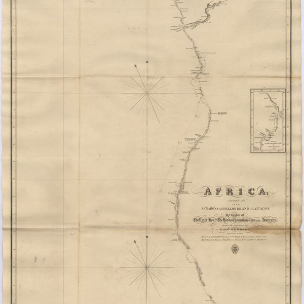
Africa : Sheet III : from Annabona to Hollams Island in Latde. 24º 36' S
Cartografia
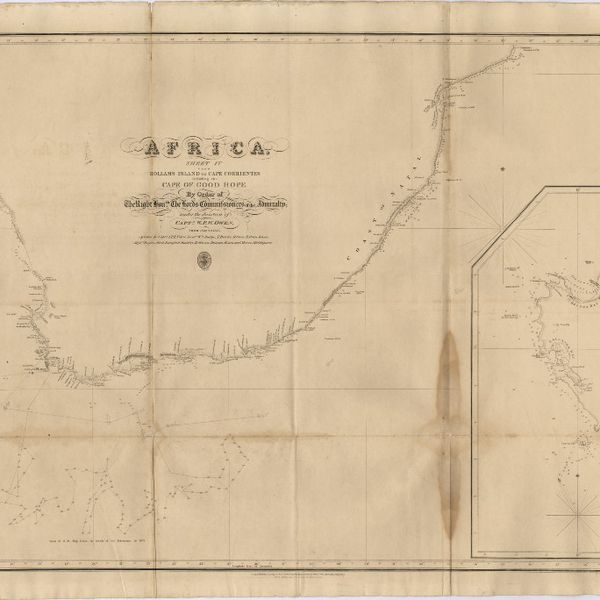
Africa : Sheet IV : from Hollams Island to Cape Corrientes including the Cape of Good Hope
Cartografia
Africa : Sheet V : from Cape Corrientes to Juba Islands including Madagascar, Comoro, Zanzibar, Ids. & c.
Cartografia
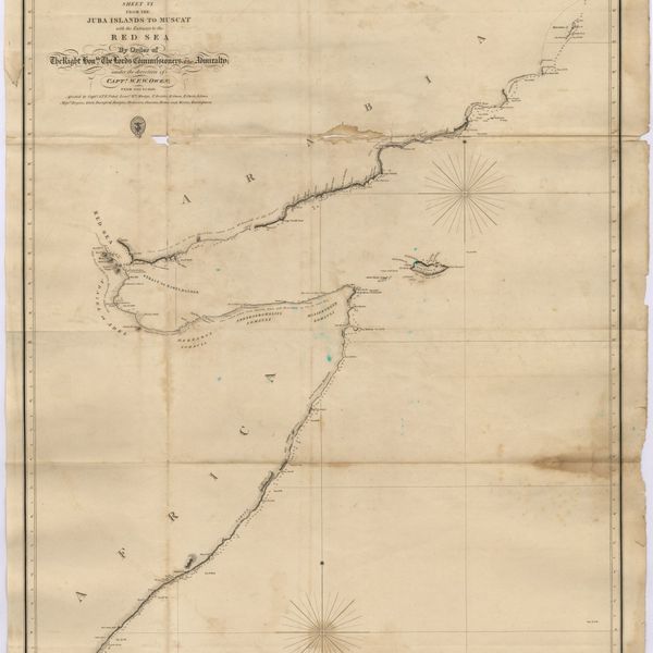
Africa : Sheet VI : from the Juba Islands to Muscat : with the Entrance to the Red Sea
Cartografia
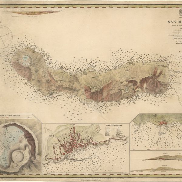
Azores : San Miguel
Cartografia
Bay of Biscay : from the latest information in the hydrographic Dept. to 1953
Gravuras e Desenhos
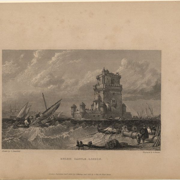
Belem castle, Lisbon
Cartografia
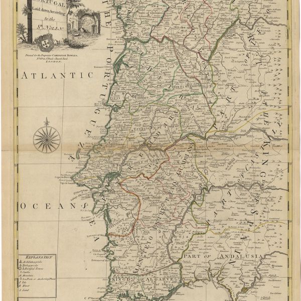
Bowles's new pocket map of Portugal
Cartografia
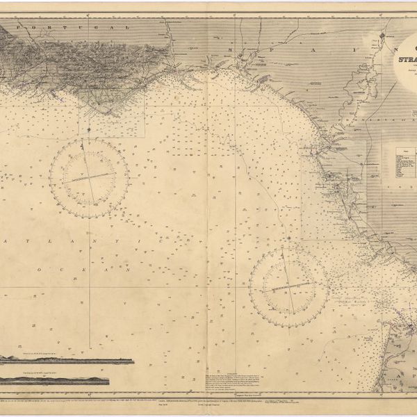
Cape St. Vincent to the Strait of Gibraltar : compiled from the latest government charts
Cartografia
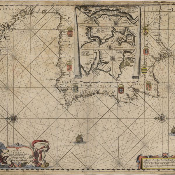
A chart of Spaine : perticulerly discribing the coasts of Biscaia Gallissia Portugal Andaluzia Granada Ec
Cartografia
A Chart of the Açores (Hawks) Islands, called also Flemish and Western Islands from Mr. D'Anviille with several additions.
Cartografia
Chart of the Açores (Hawks) Islands, called also Flemish and Western Islands.
Cartografia
Chart of the Açores (Hawks) Islands, called also Flemish and Western Islands.
Cartografia
Chart of the Island of St. Michael
Cartografia
A Chart of the Maderas and Canary Islands : from the Draughts and Memoirs of Captn. George Glas : Regulated and Ascertained by Astronomical Observations.
Cartografia
A chart of the sea coasts of Algrave [sic] and Andalusia between cape St. Vincent and the strait of Gibralter and c. Spartel
Cartografia
A chart of the West Coast of Africa : Sheet VIII : the Isles de Los to Sherboro Island
Cartografia
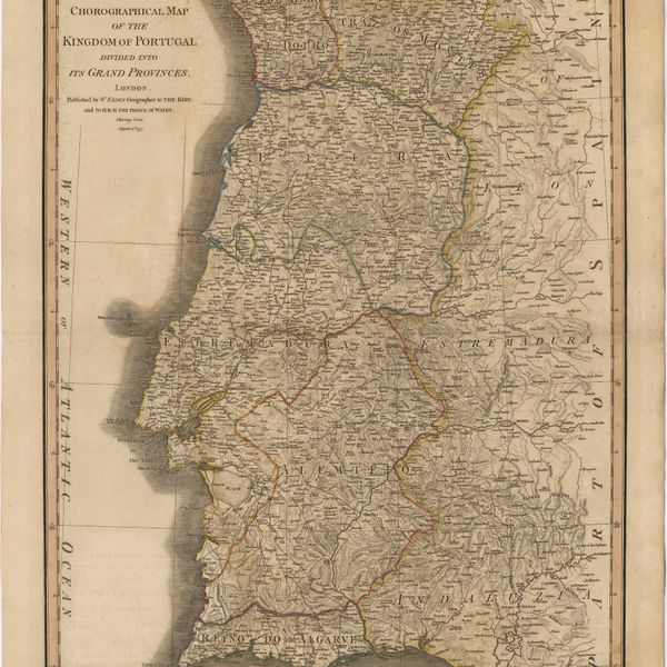
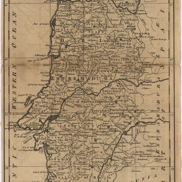
Chorographical map of the kingdom of Portugal divided into its grand provincies = Mappa corografico do Reino de Portugal
Cartografia
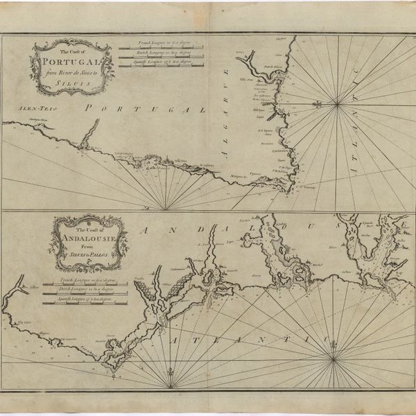
The Coast of Portugal from River de Sinis to Siluis ; The coast of Andalousie from Siluis to Pallos.
Gravuras e Desenhos
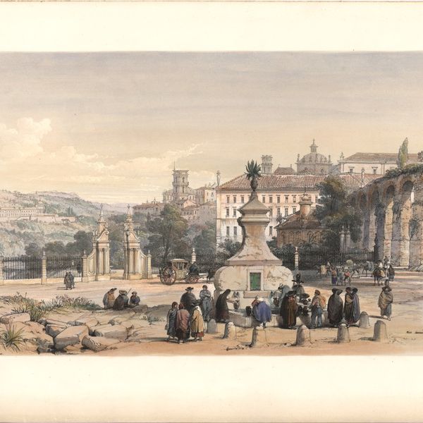
Coimbra
Gravuras e Desenhos
Coimbra from the east
Gravuras e Desenhos
[Coimbra]
Cartografia
A correct map of Spain & Portugal : according to the newest observations and discoveries comunicated to the Royal Society at London and the Royal Academy at Paris is humbly dedicated to the Right Honorable Iohn Ld. Somers Baron of Evesham
Gravuras e Desenhos
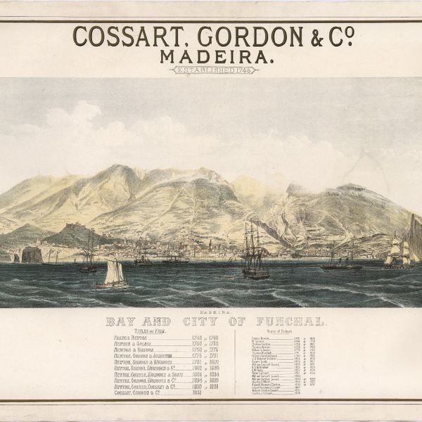
Cossart, Gordon & Cº. : Madeira : established 1745
Cartografia
The Delta of the River Kowara or Quorra, the ancient Niger
Livro Moderno
Florulae Salvagicae Tentamen or a list of plants collected in the Salvages or Salvage Islands by Sr Constantino Cabral de Noronha and communicated by The Barão do Castello de Paiva
Cartografia
France : West Coast : Entrance to La Gironde : from the french government charts of 1887 : with additions and corrections to 1955
Cartografia
France : West Coast : La Gironde Royan to Bordeaux : from the french government chart of 1914 : with additions and corrections to 1954
Cartografia
France : West Coast : Pertuis d'Antioche with the approaches to La Rochelle and Rochefort : from the latest french government charts to 1950 : with additions and corrections to 1953
Cartografia
France North Coast : Sheet VIII : Ushant to Plateau des Roches Douvres : from the pilote français 1823 : with additions and corrections to 1911
Cartografia
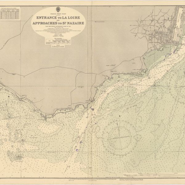
France West Coast : entrance to La Loire and approaches to St. Nazaire : from the French Government Charts of 1893 : with corrections to 1954
Cartografia
France West Coast : Ile d'Ouessant to St. Nazaire : from the French Government Charts to 1939
Cartografia
France West Coast : La Loire St. Nazaire to Nantes : from French Government Charts to 1948 : with corrections to 1948
Cartografia
France West Coast Sheet III : Pte. de la Coubre to les Sables d'Olonne : from the French Government Charts to 1940
Cartografia
France West Coast Sheet IV : Les Sables d'Olonne to Bourgneuf : from the Pilote Francais with corrections from French Government Charts to 1924
Cartografia
France West Coast Sheet V : Bourgneuf to I. de Groix : from the Pilote Francais with corrections from French Government Charts to 1949
Cartografia
France West Coast Sheet VI : I. de Groix to Raz de Sein : from the French Government Charts of 1828 : with corrections to 1933
Cartografia
France-North West Coast : Sheet VII : Raz de Sein to Goulven including Brest and Ushant : from French Government Charts to 1919
Gravuras e Desenhos
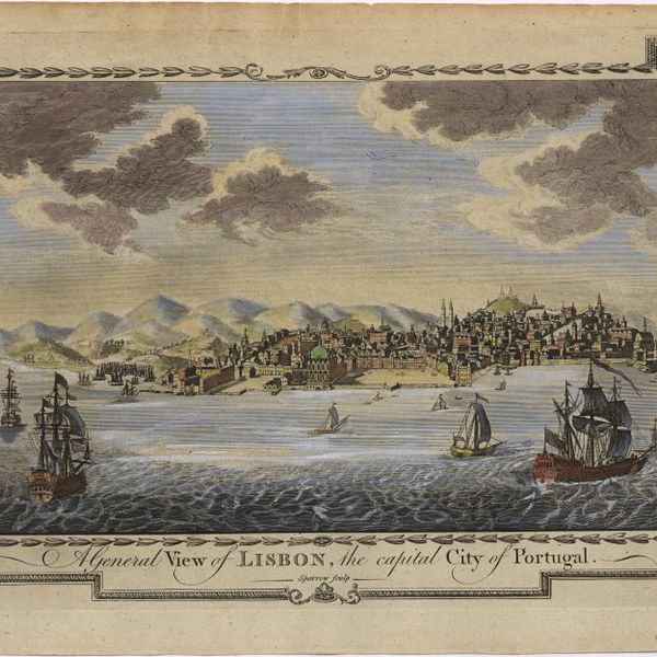
A general view of Lisbon, the capital city of Portugal
Gravuras e Desenhos
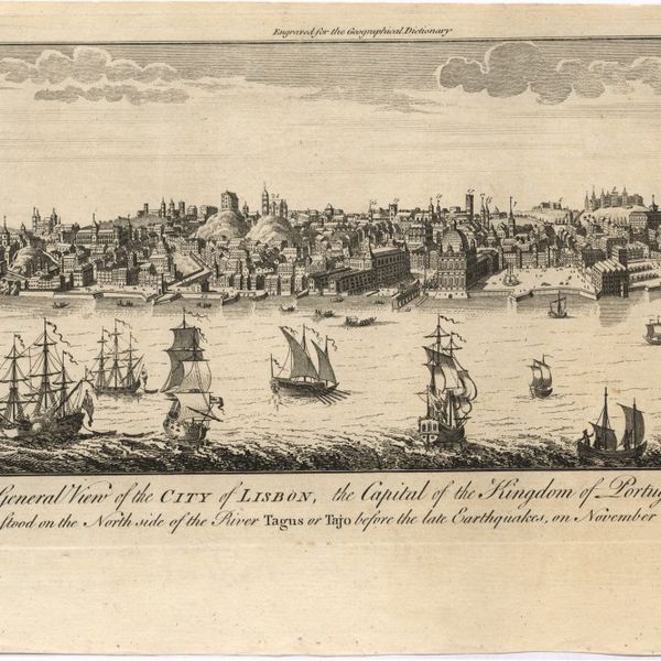
A general view of the city of Lisbon, the capital of the Kingdom of Portugal as it stood on the North side of the river Tagus or Tajo before the late earthquakes, on November 1.st & 8.th 1755
Cartografia
Island of Madeira
Cartografia
The Island of Madeira (Portuguese)
Cartografia
Island of Madera ; The Dragon Tree
Cartografia
Islands in the Atlantic
Cartografia
The islands of Madeira, Porto santo and Dezertas
Cartografia
The Kingdoms of Portugal and Algarve from Zannonïs Map
Cartografia
The Kingdoms of Portugal and Algarve from Zannonïs Map
Manuscrito
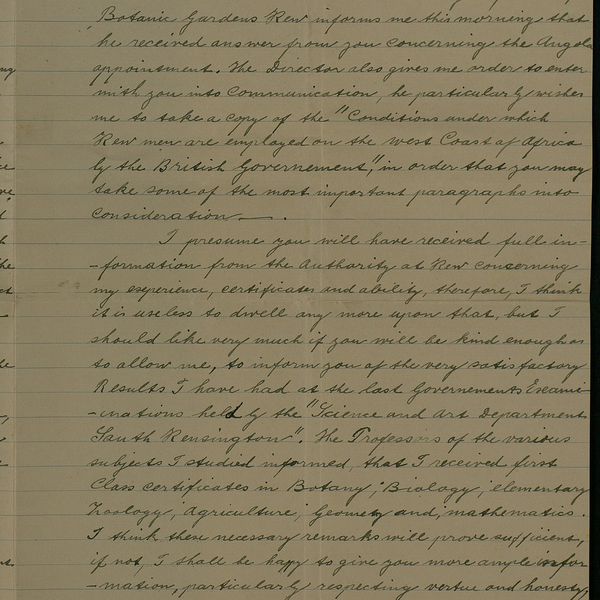
[Letter], 1876 Aug. 31, [Kew, to] Sir [Júlio Henriques, Coimbra]
Manuscrito
[Letter], 1876 Nov. 30, Kew, [to] Sir [Júlio Henriques, Coimbra]
Manuscrito
[Letter], 1876 Oct. 3, [Kew, to] Sir [Júlio Henriques, Coimbra]
Manuscrito
[Letter], 1877 Aug. 13, [Kew, to] Sir [Júlio Henriques, Coimbra]
Manuscrito
[Letter], 1877 Feb. 8, [Kew, to] Sir [Júlio Henriques, Coimbra]
Manuscrito
[Letter], 1878 Apr. 18, [Kew, to] Sir [Júlio Henriques, Coimbra]
Manuscrito
[Letter], 1878 Mar. 21, [Kew, to] Sir [Júlio Henriques, Coimbra]
Manuscrito
[Letter], 1878 Mar. 26, [Kew, to] Sir [Júlio Henriques, Coimbra]
Manuscrito
[Letter], 1878 May 1, [Kew, to] Sir [Júlio Henriques, Coimbra]
Manuscrito
[Letter], 1878 May 18, [Kew, to Júlio Henriques, Coimbra]
Manuscrito
[Letter], 1879 July 2, [Kew, to Júlio Henriques, Coimbra]
Manuscrito
[Letter], 1881 June 27, [Kew, to Júlio Henriques, Coimbra]
Manuscrito
[Letter], 1883 July 16, Kew, [to Júlio Henriques, Coimbra]
Manuscrito
[Letter], 1883 Oct. 25, Kew, [to Júlio Henriques, Coimbra]
Manuscrito
[Letter], 1884 June 6, Kew, [to Júlio Henriques, Coimbra]
Manuscrito
[Letter], 1884 May 20, Kew, [to Júlio Henriques, Coimbra]
Manuscrito
[Letter], 1885 Oct. 24, Kew, [to Júlio Henriques, Coimbra]
Manuscrito
[Letter], 1887 Aug. 2, [Kew, to] Dr. [Júlio] Henriques, [Coimbra]
Manuscrito
[Letter], 1888 July 28, London, [to] Professor J. A. Henriques, Coimbra
Manuscrito
[Letter], 1888 Mar. 19, [Kew, to] Dr [Júlio] Henriques, [Coimbra]
Manuscrito
[Letter], 1893 July 6, London, [to Júlio Henriques, Coimbra]
Manuscrito
[Letter], 1894 Nov. 20, London, [to Júlio Henriques, Coimbra]
Manuscrito
[Letter], 1895 Oct. 12, Londres, [to Júlio Henriques, Coimbra]
Manuscrito
[Letter], 1895 Oct. 28, Londres, [to Júlio Henriques, Coimbra]
Manuscrito
[Letter], 1898 Nov. 30, London, [to] Dr. J. Henriques, Coimbra
Manuscrito
[Letter], 1898 Oct. 20, London, [to] Mr. J. A. Henriques, Coimbra
Manuscrito
[Letter], 1900 July 2, London, [to] Dr. J. A. Henriques, Coimbra
Manuscrito
[Letter], 1903 May 08, The Herbarium, [Kew], [to Júlio] Henriques, [Coimbra]
Manuscrito
[Letter], 1906 Dec. 28, London, [to] Dr. J. A. Henriques, Coimbra
Manuscrito
[Letter], 1911 Mar. 11, Kew, [to] Dr. J. A. Henriques, Coimbra
Manuscrito
[Letter], 1912 Oct. 3, Kew, [to] Prof. J. A. Henriques, Coimbra
Manuscrito
[Letter], 1915 Jan. 4, Kew, [to] Prof. J. A. Henriques, Coimbra
Manuscrito
[Letter], 1916 Oct. 25, Kew, [to] Monsieur le Prof. J. Henriques, Coimbra
Manuscrito
[Letter], 1921 Mar. 01, The Herbarium, Royal Botanic Gardens, Kew, Surrey, [to Júlio Henriques, Coimbra]
Manuscrito
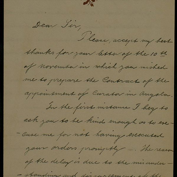
[Letter], 1929 Jan. 26, London, [to] Dr. Carrisso, [Coimbra]
Manuscrito
[Letter], 1934 Mar. 27, London, [to] Professor A. Quintanilha, Coimbra
Correspondência
[Letter], 1934 Mar. 27, London, [to] Professor A. Quintanilha, Coimbra
Cartografia
Lisbon = Lisboa
Cartografia
Madrid
Cartografia
Map of Portugal
Cartografia
Map of South America : For the Ver. Dr. Robertson's History of America
Cartografia
A map of the Kingdom of Portugal
Cartografia
A Map of the River Tale to Lisbon Done from a New Survey
Cartografia
Map of the wine district of the Alto-Douro
Cartografia
Mediterranean : Africa : C. Tres Forcas to C. Ivi : surveyed by Captain E. Mouchez of the french Navy 1870-73
Cartografia
Mediterranean : Algeria : Algiers to C. Bougaroni : surveyed by Captain E. Mouchez of the french Navy 1867-9 : with corrections from the french gouvernment charts 1925-1926
Cartografia
Mediterranean : Algeria : Ports d'Oran and Mers-el-Kébir : from the french government chart of 1876 : with corrections to 1953
Cartografia
Mediterranean : Algeria : Tunis : C. Bougaroni to Fratelli Rocks including Galita Channel
Cartografia
Mediterranean : Algeric : approaches to Bone : from french government chart 1889 : with corrections from the french government chart 1929
Cartografia
Mediterranean : Algérie : C. Ivi to Alger : from the french government charts of 1867-1870 : with additions and corrections to 1951
Cartografia
Mediterranean : Coast of Palestine : Tyre to El Arish
Cartografia
Mediterranean : Gibraltar : surveyed by Capt. R. M. Southern R. N. and officers of H. M. Surveying ship "Challenger" : 1947-1948