Os cookies.
Este site utiliza cookies para lhe proporcionar uma melhor experiência de utilização.
OK, ACEITO
Sobre
Itens da coleção
Refinar a pesquisa
Coleções digitais
Biblioteca Geral
Mapas Nabais Conde
148
500 Anos da Biblioteca
4
EU
1
Tipo
Cartografia
137
Gravuras e Desenhos
11
Livro Antigo
6
Autor
Walker, J. & C.
17
Vidal, Alexander Thomas Emeric
11
Owen, William Fitzwilliam
10
Edgell, J. A.
8
Wharton, W. J. L.
8
Ver mais
Data
1876-1926
9
1832-1840
10
1760-1775
12
1710-1750
9
1620-1700
9
Ver mais
Local de publicação
Londres
Nova Iorque
2
Dublin
1
Edimburgo
1
Assunto
Mapa
76
Portugal
37
Mar Mediterrâneo
28
Costa Ocidental
23
Oceano Atlântico
23
Ver mais
Idioma
Inglês
143
Português
7
Latim
3
Italiano
1
PT
EN
PT
EN
Biblioteca de Fundo Antigo da UC
Almamater
Em destaque
Todos os itens
Sobre
Nesta coleção
Pesquisa avançada
Refinar a pesquisa
Limpar
Coleções digitais
Biblioteca Geral
Mapas Nabais Conde
148
500 Anos da Biblioteca
4
EU
1
Tipo
Cartografia
137
Gravuras e Desenhos
11
Livro Antigo
6
Autor
Walker, J. & C.
17
Vidal, Alexander Thomas Emeric
11
Owen, William Fitzwilliam
10
Edgell, J. A.
8
Wharton, W. J. L.
8
Ver mais
Data
1876-1926
9
1832-1840
10
1760-1775
12
1710-1750
9
1620-1700
9
Ver mais
Local de publicação
Londres
Nova Iorque
2
Dublin
1
Edimburgo
1
Assunto
Mapa
76
Portugal
37
Mar Mediterrâneo
28
Costa Ocidental
23
Oceano Atlântico
23
Ver mais
Idioma
Inglês
143
Português
7
Latim
3
Italiano
1
Itens
154
Ver como
Galeria
Lista
Grelha
Ordenar por
Título
Título (descendente)
Data (de publicação)
Data (descendente)
Páginas
1
2
Limite por página
50
100
250
Cartografia
Africa : Sheet II : from the River Gambia to cape Lopez and Annabona including the Bight of Biafra
Cartografia
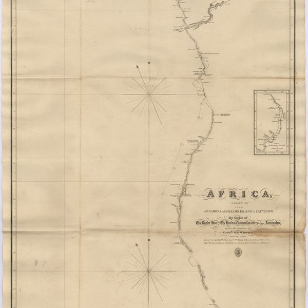
Africa : Sheet III : from Annabona to Hollams Island in Latde. 24º 36' S
Cartografia
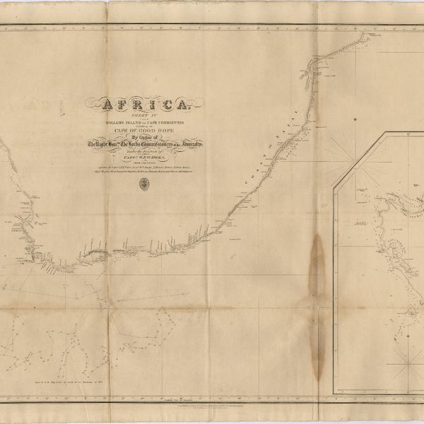
Africa : Sheet IV : from Hollams Island to Cape Corrientes including the Cape of Good Hope
Cartografia
Africa : Sheet V : from Cape Corrientes to Juba Islands including Madagascar, Comoro, Zanzibar, Ids. & c.
Cartografia
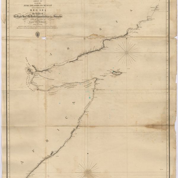
Africa : Sheet VI : from the Juba Islands to Muscat : with the Entrance to the Red Sea
Cartografia
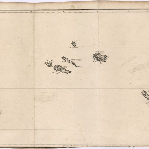
Azores
Cartografia
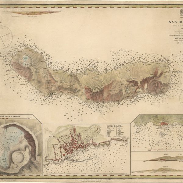
Azores : San Miguel
Cartografia
Bay of Biscay : from the latest information in the hydrographic Dept. to 1953
Gravuras e Desenhos
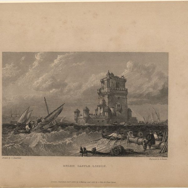
Belem castle, Lisbon
Cartografia
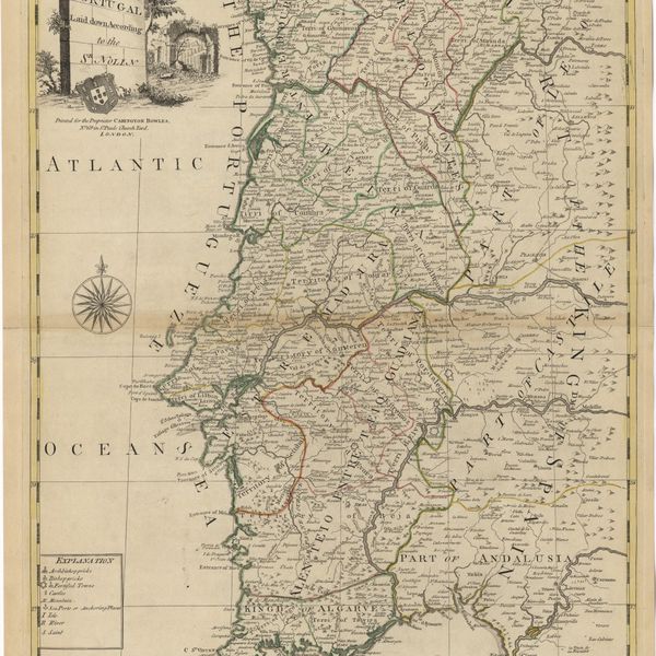
Bowles's new pocket map of Portugal
Cartografia
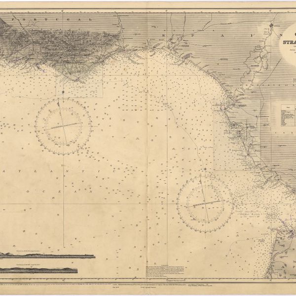
Cape St. Vincent to the Strait of Gibraltar : compiled from the latest government charts
Cartografia
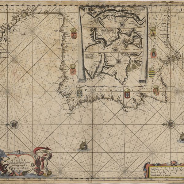
A chart of Spaine : perticulerly discribing the coasts of Biscaia Gallissia Portugal Andaluzia Granada Ec
Cartografia
A Chart of the Açores (Hawks) Islands, called also Flemish and Western Islands from Mr. D'Anviille with several additions.
Cartografia
Chart of the Açores (Hawks) Islands, called also Flemish and Western Islands.
Cartografia
Chart of the Açores (Hawks) Islands, called also Flemish and Western Islands.
Cartografia
Chart of the Island of St. Michael
Cartografia
A Chart of the Maderas and Canary Islands : from the Draughts and Memoirs of Captn. George Glas : Regulated and Ascertained by Astronomical Observations.
Cartografia
A chart of the sea coasts of Algrave [sic] and Andalusia between cape St. Vincent and the strait of Gibralter and c. Spartel
Cartografia
A chart of the West Coast of Africa : Sheet VIII : the Isles de Los to Sherboro Island
Cartografia
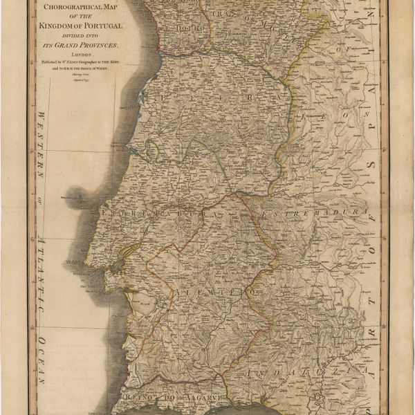
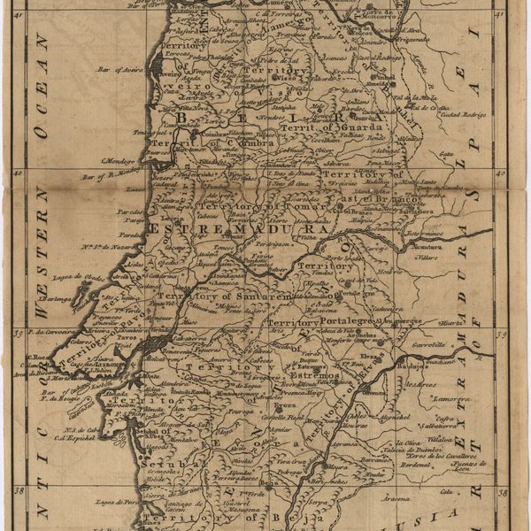
Chorographical map of the kingdom of Portugal divided into its grand provincies = Mappa corografico do Reino de Portugal
Cartografia
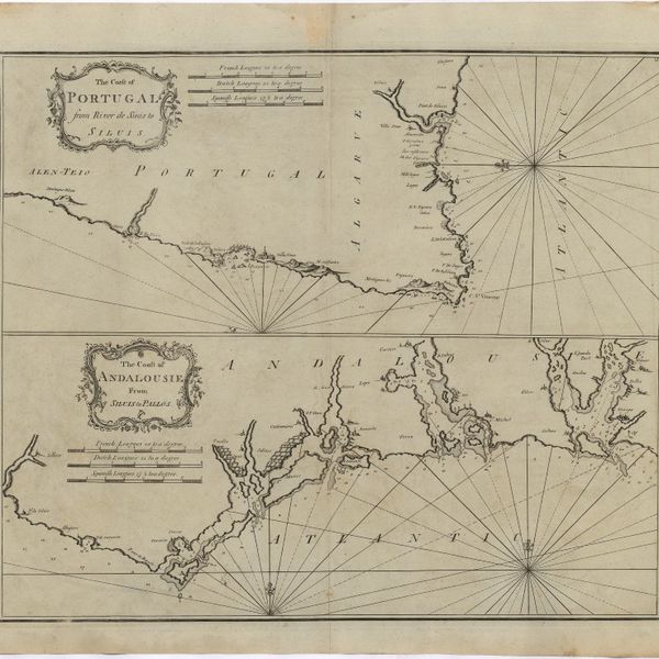
The Coast of Portugal from River de Sinis to Siluis ; The coast of Andalousie from Siluis to Pallos.
Gravuras e Desenhos
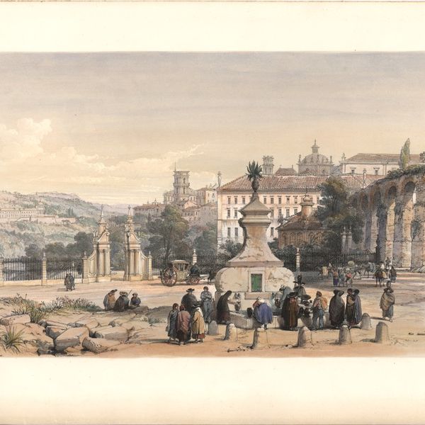
Coimbra
Gravuras e Desenhos
Coimbra from the east
Gravuras e Desenhos
[Coimbra]
Cartografia
A correct map of Spain & Portugal : according to the newest observations and discoveries comunicated to the Royal Society at London and the Royal Academy at Paris is humbly dedicated to the Right Honorable Iohn Ld. Somers Baron of Evesham
Gravuras e Desenhos
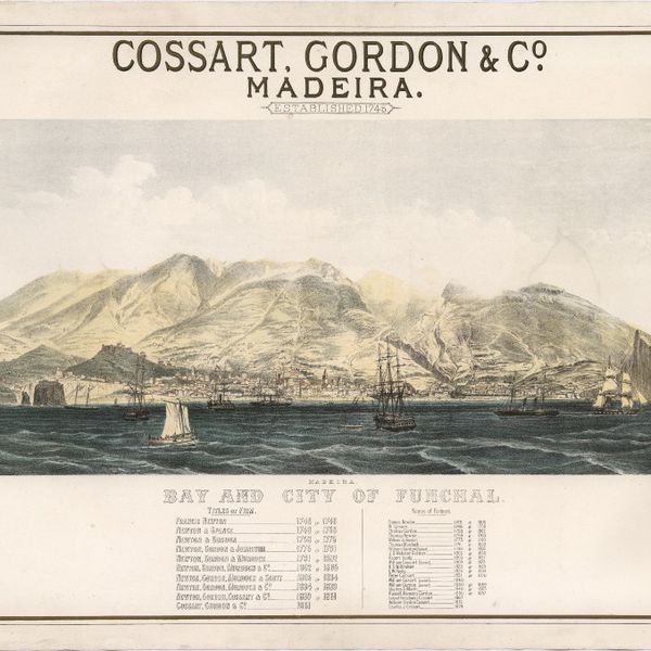
Cossart, Gordon & Cº. : Madeira : established 1745
Cartografia
The Delta of the River Kowara or Quorra, the ancient Niger
Livro Antigo
Do uso, e abuso das minhas Agoas de Inglaterra, ou Directorio, e instruccam, para se saber seguramente, quando se deve, ou naõ, usar dellas, assim nas enfermedidades agudas; como em algumas chronicas; e em casos propriamente de cirurgia
Livro Antigo
La festa d'amore per le nozze de' Reali Prencipi Don Giuseppe Prencipe del Brasile, con Donna Maria Infanta di Spagna, e di Don Ferdinando Prencipe dell' asturie, con Donna Maria Infanta di Portugallo ...
Cartografia
France : West Coast : Entrance to La Gironde : from the french government charts of 1887 : with additions and corrections to 1955
Cartografia
France : West Coast : La Gironde Royan to Bordeaux : from the french government chart of 1914 : with additions and corrections to 1954
Cartografia
France : West Coast : Pertuis d'Antioche with the approaches to La Rochelle and Rochefort : from the latest french government charts to 1950 : with additions and corrections to 1953
Cartografia
France North Coast : Sheet VIII : Ushant to Plateau des Roches Douvres : from the pilote français 1823 : with additions and corrections to 1911
Cartografia
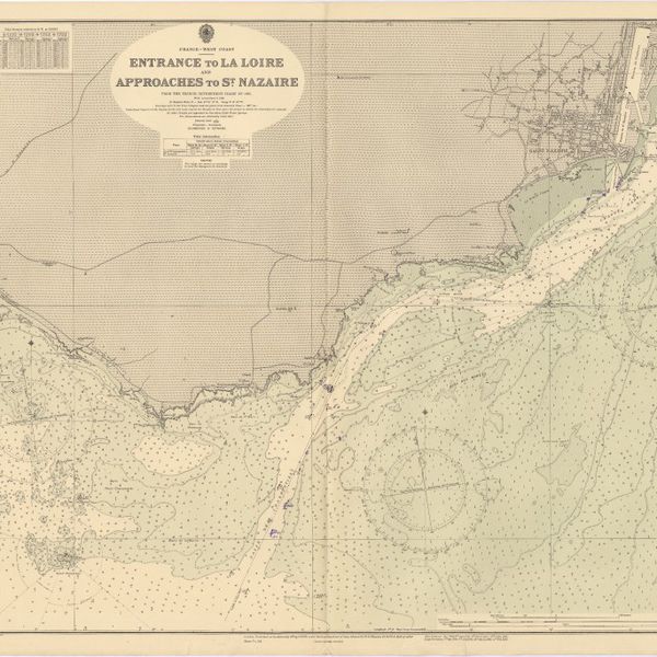
France West Coast : entrance to La Loire and approaches to St. Nazaire : from the French Government Charts of 1893 : with corrections to 1954
Cartografia
France West Coast : Ile d'Ouessant to St. Nazaire : from the French Government Charts to 1939
Cartografia
France West Coast : La Loire St. Nazaire to Nantes : from French Government Charts to 1948 : with corrections to 1948
Cartografia
France West Coast Sheet III : Pte. de la Coubre to les Sables d'Olonne : from the French Government Charts to 1940
Cartografia
France West Coast Sheet IV : Les Sables d'Olonne to Bourgneuf : from the Pilote Francais with corrections from French Government Charts to 1924
Cartografia
France West Coast Sheet V : Bourgneuf to I. de Groix : from the Pilote Francais with corrections from French Government Charts to 1949
Cartografia
France West Coast Sheet VI : I. de Groix to Raz de Sein : from the French Government Charts of 1828 : with corrections to 1933
Cartografia
France-North West Coast : Sheet VII : Raz de Sein to Goulven including Brest and Ushant : from French Government Charts to 1919
Livro Antigo
Francisci Baconi, Baronis de Verulamio ... Operum moralium et civilium tomus, qui continet Historiam regni Henrici septimi, regis Angliae. Sermones fideles, sive interior a rerum. Tractatum de sapientiâ veterum. Dialogum de bello sacro. Et Novam atlantid
Livro Antigo
Francisci de Verulamio ... Instauratio magna
Gravuras e Desenhos
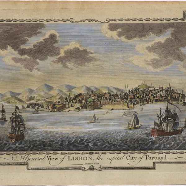
A general view of Lisbon, the capital city of Portugal
Gravuras e Desenhos
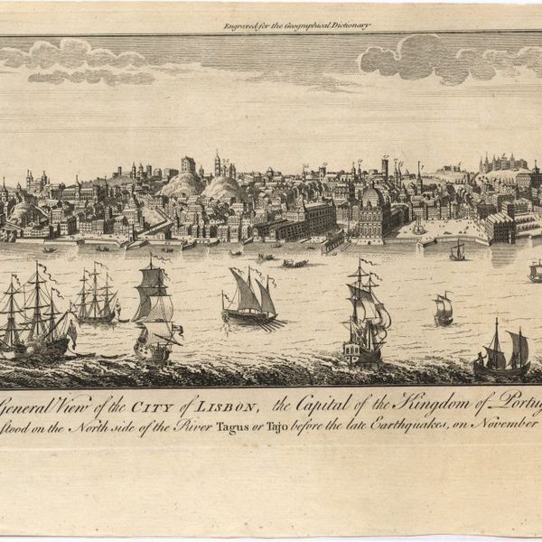
A general view of the city of Lisbon, the capital of the Kingdom of Portugal as it stood on the North side of the river Tagus or Tajo before the late earthquakes, on November 1.st & 8.th 1755
Gravuras e Desenhos
Illustrissima Catharina Mag: Brit: Fran: & Hiber Regina
Cartografia
Island of Madeira
Cartografia
The Island of Madeira (Portuguese)
Cartografia
Island of Madera ; The Dragon Tree
Cartografia
Islands in the Atlantic
Cartografia
The islands of Madeira, Porto santo and Dezertas
Cartografia
The Kingdoms of Portugal and Algarve from Zannonïs Map
Cartografia
The Kingdoms of Portugal and Algarve from Zannonïs Map
Cartografia
Lisbon = Lisboa
Cartografia
Madrid
Cartografia
Map of Portugal
Cartografia
Map of South America : For the Ver. Dr. Robertson's History of America
Cartografia
A map of the Kingdom of Portugal
Cartografia
A Map of the River Tale to Lisbon Done from a New Survey
Cartografia
Map of the wine district of the Alto-Douro
Cartografia
Mappa ou carta geographica dos reinos de Portugal e Algarve
Cartografia
Mappa ou carta geographica dos reinos de Portugal e Algarve
Cartografia
Mediterranean : Africa : C. Tres Forcas to C. Ivi : surveyed by Captain E. Mouchez of the french Navy 1870-73
Cartografia
Mediterranean : Algeria : Algiers to C. Bougaroni : surveyed by Captain E. Mouchez of the french Navy 1867-9 : with corrections from the french gouvernment charts 1925-1926
Cartografia
Mediterranean : Algeria : Ports d'Oran and Mers-el-Kébir : from the french government chart of 1876 : with corrections to 1953
Cartografia
Mediterranean : Algeria : Tunis : C. Bougaroni to Fratelli Rocks including Galita Channel
Cartografia
Mediterranean : Algeric : approaches to Bone : from french government chart 1889 : with corrections from the french government chart 1929
Cartografia
Mediterranean : Algérie : C. Ivi to Alger : from the french government charts of 1867-1870 : with additions and corrections to 1951
Cartografia
Mediterranean : Coast of Palestine : Tyre to El Arish
Cartografia
Mediterranean : Gibraltar : surveyed by Capt. R. M. Southern R. N. and officers of H. M. Surveying ship "Challenger" : 1947-1948
Cartografia
Mediterranean : Israel : Bay of Acre ; Acre Anchorage ; Haifa Harbour
Cartografia
Mediterranean : Libya : Porto di Tripoli
Cartografia
Mediterranean : Tunis : Fratelli Rocks to Mahedia
Cartografia
Mediterranean : Tunisia : Baie de Tunis : from the french Gouvernment charts of 1893 : with corrections to 1953
Cartografia
Mediterranean : Tunisia : North Coast : Lac de Bizerte and Entrance : from french government charts to 1948 : with corrections to 1957
Cartografia
Mediterranean Sea : Algérie : C. Ferrat to C. Bougaroni : from the french government surveys of 1868-74 : the coast of Spain from spanish authorities
Cartografia
Mediterranean Sea : Algeria : approaches to Alger : from the french government charts to 1932 : with corrections to 1950
Cartografia
Mediterranean Sea : Algeria : Port d'Alger : from the french government chart of 1911 : with corrections to 1938
Cartografia
Mediterranean Sea : Egypt : Alexandria Harbour
Cartografia
Mediterranean Sea : Egypt : Alexandria to Port Saïd
Cartografia
Mediterranean Sea : Egypt : approaches to Port Said ; Port Said
Cartografia
Mediterranean Sea : Egypt : Damietta to El Arish
Cartografia
Mediterranean Sea : Europe Gibraltar to Alicante : Africa Cape Spartel to Cape Ferrat : from spanish and french government charts to 1877
Cartografia
Mediterranean Sea : Libya : Ras Ashdir to Sirte : from the italian Gouvernment charts of 1931-32
Cartografia
Mediterranean Sea : Marocco : Bahia de Ceuta : from the Spanish Gouvernment Chart of 1926 : with corrections to 1956
Cartografia
Mediterranean Sea : plans of the Coast of Libya : Rada and Porto di Tripoli : from the italian Gouvernment chart of 1930
Cartografia
Mediterranean Sea : Tunisia : East Coast : approaches to Sfax : from the french Gouvernment charts to 1952 : with corrections to 1953
Cartografia
Mediterranean Sea : Tunisia : East Coast : Kélibia to Tripoli : principally from french and italian Gouvernment charts to 1954
Livro Antigo
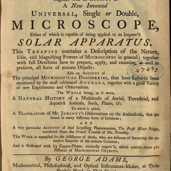
Micrographia illustrata, or, The knowledge of the microscope explain'd together with an account of a New Invented Universal, single or double, Microscope, either of which is capable of being applied to an Improv'd Solar Apparatus. This Treatise contains a Description of the Nature, Uses, and Magnifysing Powers of Microscopes in general; together with full Directions how to prepare, apply, and examine, as well as preserve, all Sorts of minute Objects also an account of The principal Microcopical Discoveries, that have hirherto been mentioned by the most celebrated Authors, togeher with a great Variety of new Experiments and Observations. The whole being, as it were, A Natural History of a Multitude of Aerial, Terrestrial, and Aquatick Animals, Seeds, Plants, Etc. To which is added, A Translation of Mr. Joblott's Observations on the Animalcula, that are found in many different Sorts of Infusions and a very particular Account of the surprising Phaenomenon, The Fresh Water Polype, translated from the French Treatise of Mr. Trembley. This Work is compiled for the Assistance of those, who are desirous of surveyng the extensive Beauties of the minute Creation and is illustreted with 65 Copper-plates, curiously engrav'd, wich contain above 560 Pictures of Microscopic Objets
Cartografia
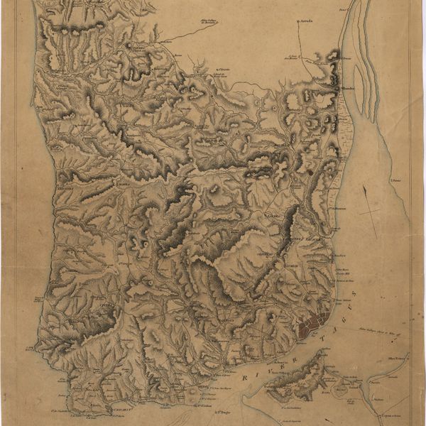
A Military sketch of the country between Lisbon and Vimiero occupied by the British Army under the command of Lieutenant General Viscount Wellington
Livro Antigo
The mourning bride : a tragedy
Cartografia
A new and accurate map of Portugal : composed from the latest improvem.ts and adjusted by the most authentic astron. observats.
Cartografia
A new and accurate map of Spain and Portugal : drawn from the best Authorities
Cartografia
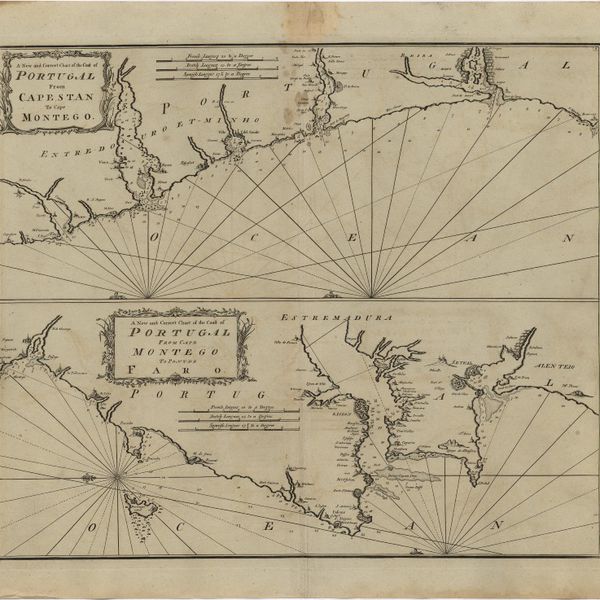
A new and correct chart of the coast of Portugal from Cape Stan to Cape Montego ; A new and correct chart of the coast of Portugal from Cape Montego to Pont de Faro
Cartografia
A new map of Iberia Europaea alias Celtiberia, or Ancient Spain : shewing its principal divisions, cheif cities, townes, rivers, mountains & c[?]. Dedicated to His Highness William Duke of Gloucester
Cartografia
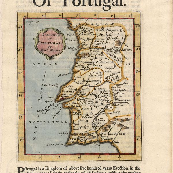
A new map of Portugal
Cartografia
A new map of present Spain & Portugal : shewing their principal divisions, cheif cities, townes, rivers, mountains & c. : Dedicated to His Highness William Duke of Gloucester
Cartografia
A new map of Spain and Portugal : exhibiting the chains of mountains with their passes, the principal & cross roads, with other details requisite for the intelligence of Military Operations
Cartografia
A new map of Spain and Portugal : exhibiting the chains of mountains with their passes, the principal & cross roads, with other details requisite for the intelligence of Military Operations
Cartografia
A new map of the Kingdom of Portugal divided into its provinces