Os cookies.
Este site utiliza cookies para lhe proporcionar uma melhor experiência de utilização.
OK, ACEITO
Sobre
Itens da coleção
Refinar a pesquisa
Coleções digitais
Biblioteca Geral
Mapas Nabais Conde
EU
1
Tipo
Cartografia
Autor
Walker, J. & C.
24
Vidal, Alexander Thomas Emeric
14
Owen, William Fitzwilliam
10
Bedford, George Augustus
8
Edgell, J. A.
8
Ver mais
Data
1939-1952
9
1830-1840
10
1810-1824
10
1756-1764
10
1710-1755
9
Ver mais
Local de publicação
Londres
131
Washington
8
Edimburgo
3
Nova Iorque
2
Chicago
1
Ver mais
Assunto
Mapa
79
Portugal
41
Costa Ocidental
30
Oceano Atlântico
30
Mar Mediterrâneo
28
Ver mais
Idioma
Inglês
PT
EN
PT
EN
Biblioteca de Fundo Antigo da UC
Almamater
Em destaque
Todos os itens
Sobre
Nesta coleção
Pesquisa avançada
Refinar a pesquisa
Limpar
Coleções digitais
Biblioteca Geral
Mapas Nabais Conde
EU
1
Tipo
Cartografia
Autor
Walker, J. & C.
24
Vidal, Alexander Thomas Emeric
14
Owen, William Fitzwilliam
10
Bedford, George Augustus
8
Edgell, J. A.
8
Ver mais
Data
1939-1952
9
1830-1840
10
1810-1824
10
1756-1764
10
1710-1755
9
Ver mais
Local de publicação
Londres
131
Washington
8
Edimburgo
3
Nova Iorque
2
Chicago
1
Ver mais
Assunto
Mapa
79
Portugal
41
Costa Ocidental
30
Oceano Atlântico
30
Mar Mediterrâneo
28
Ver mais
Idioma
Inglês
Itens
159
Ver como
Grelha
Lista
Galeria
Ordenar por
Título
Título (descendente)
Data (de publicação)
Data (descendente)
Páginas
1
2
3
4
Limite por página
50
100
250
Cartografia
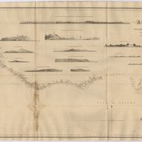
Africa : Sheet II : from the River Gambia to cape Lopez and Annabona including the Bight of Biafra
De Mayne, Anthony; Owen, William Fitzwilliam; Vidal, Alexander Thomas Emeric
Cartografia
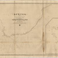
Africa : Sheet III : from Annabona to Hollams Island in Latde. 24º 36' S
Owen, William Fitzwilliam
Cartografia
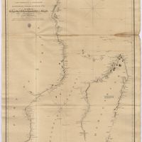
Africa : Sheet IV : from Hollams Island to Cape Corrientes including the Cape of Good Hope
Owen, William Fitzwilliam
Cartografia
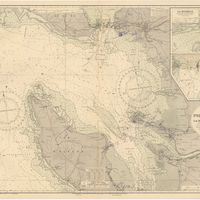
Africa : Sheet V : from Cape Corrientes to Juba Islands including Madagascar, Comoro, Zanzibar, Ids. & c.
Owen, William Fitzwilliam
Cartografia
Africa : Sheet VI : from the Juba Islands to Muscat : with the Entrance to the Red Sea
Owen, William Fitzwilliam
Cartografia
Angola : background notes
United States. Department of State. Bureau of African Affairs
Cartografia
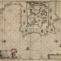
Atlantic islands
Thomson, John
Cartografia
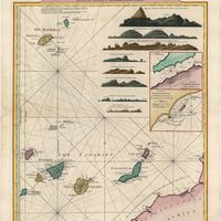
Azores : San Miguel
Vidal, Alexander Thomas Emeric
Cartografia
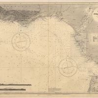
Bay of Biscay : from the latest information in the hydrographic Dept. to 1953
Day, A.
Cartografia
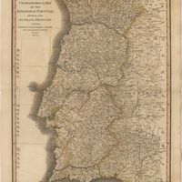
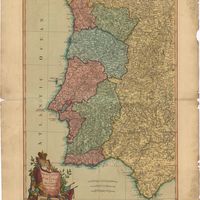
Bowles's new pocket map of Portugal
Nolin, Jean Baptiste
Cartografia
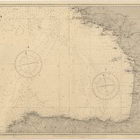
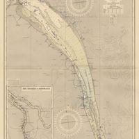
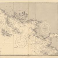
Cape St. Vincent to the Strait of Gibraltar : compiled from the latest government charts
Mostyn, A.
Cartografia
A chart of Spaine : perticulerly discribing the coasts of Biscaia Gallissia Portugal Andaluzia Granada Ec
Seller, John
Cartografia
A Chart of the Açores (Hawks) Islands, called also Flemish and Western Islands from Mr. D'Anviille with several additions.
Cartografia
Chart of the Açores (Hawks) Islands, called also Flemish and Western Islands.
Cartografia
Chart of the Açores (Hawks) Islands, called also Flemish and Western Islands.
Cartografia
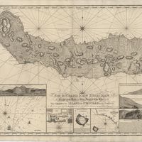
Chart of the Island of St. Michael
Read, W. Harding
Cartografia
A Chart of the Maderas and Canary Islands : from the Draughts and Memoirs of Captn. George Glas : Regulated and Ascertained by Astronomical Observations.
Cartografia
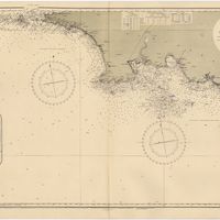
A chart of the sea coasts of Algrave [sic] and Andalusia between cape St. Vincent and the strait of Gibralter and c. Spartel
Cartografia
A chart of the West Coast of Africa : Sheet VIII : the Isles de Los to Sherboro Island
Owen, William Fitzwilliam; Boteler, T.; Vidal, Alexander Thomas Emeric
Cartografia
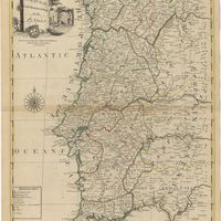
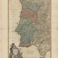
Chorographical map of the kingdom of Portugal divided into its grand provincies = Mappa corografico do Reino de Portugal
Faden, William
Cartografia
The Coast of Portugal from River de Sinis to Siluis ; The coast of Andalousie from Siluis to Pallos.
Cartografia
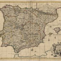
A correct map of Spain & Portugal : according to the newest observations and discoveries comunicated to the Royal Society at London and the Royal Academy at Paris is humbly dedicated to the Right Honorable Iohn Ld. Somers Baron of Evesham
Cartografia
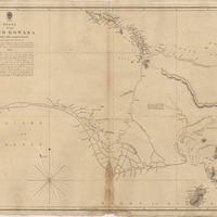
The Delta of the River Kowara or Quorra, the ancient Niger
McQueen, James
Cartografia
Europe
The Edinburgh Geographical Institute; John Bartholomew & Co.
Cartografia
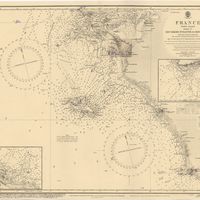
France : West Coast : Entrance to La Gironde : from the french government charts of 1887 : with additions and corrections to 1955
Wharton, W. J. L.
Cartografia
France : West Coast : La Gironde Royan to Bordeaux : from the french government chart of 1914 : with additions and corrections to 1954
Day, Archibald
Cartografia
France : West Coast : Pertuis d'Antioche with the approaches to La Rochelle and Rochefort : from the latest french government charts to 1950 : with additions and corrections to 1953
Day. A.
Cartografia
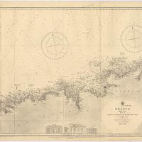
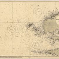
France North Coast : Sheet VIII : Ushant to Plateau des Roches Douvres : from the pilote français 1823 : with additions and corrections to 1911
Wharton, W. J. L.
Cartografia
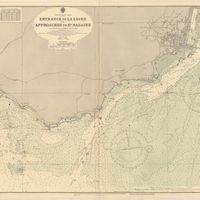
France West Coast : entrance to La Loire and approaches to St. Nazaire : from the French Government Charts of 1893 : with corrections to 1954
Wharton, W. J. L.
Cartografia
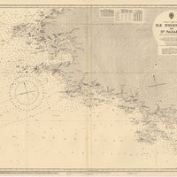
France West Coast : Ile d'Ouessant to St. Nazaire : from the French Government Charts to 1939
Edgell, John
Cartografia
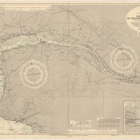
France West Coast : La Loire St. Nazaire to Nantes : from French Government Charts to 1948 : with corrections to 1948
Day. A.
Cartografia
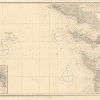
France West Coast Sheet III : Pte. de la Coubre to les Sables d'Olonne : from the French Government Charts to 1940
Edgell, John
Cartografia
France West Coast Sheet IV : Les Sables d'Olonne to Bourgneuf : from the Pilote Francais with corrections from French Government Charts to 1924
Washington, Capitão
Cartografia
France West Coast Sheet V : Bourgneuf to I. de Groix : from the Pilote Francais with corrections from French Government Charts to 1949
Washington, Capitão
Cartografia
France West Coast Sheet VI : I. de Groix to Raz de Sein : from the French Government Charts of 1828 : with corrections to 1933
Washington, Capitão
Cartografia
France-North West Coast : Sheet VII : Raz de Sein to Goulven including Brest and Ushant : from French Government Charts to 1919
Washington, Capitão
Cartografia
Iceland
Estados Unidos da América. Central Intelligence Agency
Cartografia
Iceland : background notes
Estados Unidos da América. Department of State
Cartografia
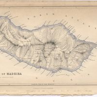
Island of Madeira
Cartografia
The Island of Madeira (Portuguese)
Cartografia
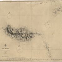
Island of Madera
Cartografia
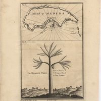
Island of Madera ; The Dragon Tree
Cartografia
Islands in the Atlantic
Cartografia
Islands in the Atlantic Ocean : Azores or Western isles (portuguese) : Faeroe Isles : Madeira Isles.
Cartografia
The islands of Madeira, Porto santo and Dezertas
Vidal, Alexander Thomas Emeric
Cartografia
The Kingdoms of Portugal and Algarve from Zannonïs Map
Rizzi-Zannoni,Giovanni Antonio
Cartografia
The Kingdoms of Portugal and Algarve from Zannonïs Map
Rizzi-Zannoni,Giovanni Antonio
Cartografia
The Kingdoms of spain and Portugal & Ca.
Cartografia
Lisbon = Lisboa
Society for the Diffusion of Useful Knowledge
Cartografia
Madrid
Society for the Diffusion of Useful Knowledge