Os cookies.
Este site utiliza cookies para lhe proporcionar uma melhor experiência de utilização.
OK, ACEITO
Mapas Nabais Conde
Sobre
Itens da coleção
Refinar a pesquisa
Tipo
Cartografia
57
Gravuras e Desenhos
8
Autor
Walker, J. & C.
17
Vidal, Alexander Thomas Emeric
12
Bedford, George Augustus
8
Edgell, J. A.
4
Washington, Capitão
4
Ver mais
Data
1868-1873
1842-1844
1841
1840
1838-1839
Ver mais
Local de publicação
Londres
52
Edimburgo
2
Nova Iorque
2
Chicago
1
Dublin
1
Ver mais
Assunto
Mapa
30
Costa Ocidental
21
Oceano Atlântico
17
Carta náutica
15
África
14
Ver mais
Idioma
Inglês
PT
EN
PT
EN
Biblioteca Geral Digital
Mapas Nabais Conde
Sobre
Itens da coleção
Nesta coleção
Pesquisa avançada
Refinar a pesquisa
Limpar
Tipo
Cartografia
57
Gravuras e Desenhos
8
Autor
Walker, J. & C.
17
Vidal, Alexander Thomas Emeric
12
Bedford, George Augustus
8
Edgell, J. A.
4
Washington, Capitão
4
Ver mais
Data
1868-1873
1842-1844
1841
1840
1838-1839
Ver mais
Local de publicação
Londres
52
Edimburgo
2
Nova Iorque
2
Chicago
1
Dublin
1
Ver mais
Assunto
Mapa
30
Costa Ocidental
21
Oceano Atlântico
17
Carta náutica
15
África
14
Ver mais
Idioma
Inglês
Itens
65
Ver como
Grelha
Lista
Galeria
Ordenar por
Título
Título (descendente)
Data (de publicação)
Data (descendente)
Limite por página
50
100
250
Cartografia
Azores : San Miguel
Vidal, Alexander Thomas Emeric
Cartografia
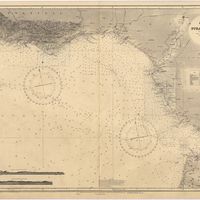
Cape St. Vincent to the Strait of Gibraltar : compiled from the latest government charts
Mostyn, A.
Cartografia
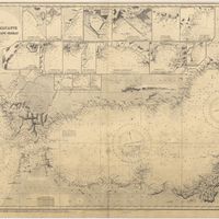
A chart of the West Coast of Africa : Sheet VIII : the Isles de Los to Sherboro Island
Owen, William Fitzwilliam; Boteler, T.; Vidal, Alexander Thomas Emeric
Gravuras e Desenhos
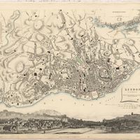
Coimbra
Holland, James
Gravuras e Desenhos
Coimbra : looking over the gardens of Santa Cruz
Vivian, George
Gravuras e Desenhos
Coimbra from the east
Vivian, George
Gravuras e Desenhos
[Coimbra]
Vivian, George
Gravuras e Desenhos
Cossart, Gordon & Cº. : Madeira : established 1745
Cartografia
The Delta of the River Kowara or Quorra, the ancient Niger
McQueen, James
Cartografia
France : West Coast : La Gironde Royan to Bordeaux : from the french government chart of 1914 : with additions and corrections to 1954
Day, Archibald
Cartografia
France North Coast : Sheet VIII : Ushant to Plateau des Roches Douvres : from the pilote français 1823 : with additions and corrections to 1911
Wharton, W. J. L.
Cartografia
France West Coast : Ile d'Ouessant to St. Nazaire : from the French Government Charts to 1939
Edgell, John
Cartografia
France West Coast Sheet III : Pte. de la Coubre to les Sables d'Olonne : from the French Government Charts to 1940
Edgell, John
Cartografia
France West Coast Sheet IV : Les Sables d'Olonne to Bourgneuf : from the Pilote Francais with corrections from French Government Charts to 1924
Washington, Capitão
Cartografia
France West Coast Sheet V : Bourgneuf to I. de Groix : from the Pilote Francais with corrections from French Government Charts to 1949
Washington, Capitão
Cartografia
France West Coast Sheet VI : I. de Groix to Raz de Sein : from the French Government Charts of 1828 : with corrections to 1933
Washington, Capitão
Cartografia
France-North West Coast : Sheet VII : Raz de Sein to Goulven including Brest and Ushant : from French Government Charts to 1919
Washington, Capitão
Cartografia
Island of Madeira
Cartografia
The Island of Madeira (Portuguese)
Cartografia
Islands in the Atlantic
Cartografia
Islands in the Atlantic Ocean : Azores or Western isles (portuguese) : Faeroe Isles : Madeira Isles.
Cartografia
The islands of Madeira, Porto santo and Dezertas
Vidal, Alexander Thomas Emeric
Cartografia
Lisbon = Lisboa
Society for the Diffusion of Useful Knowledge
Gravuras e Desenhos
[Lisbon].
Cartografia
Map of the wine district of the Alto-Douro
Forrester, Joseph James
Cartografia
Mediterranean : Africa : C. Tres Forcas to C. Ivi : surveyed by Captain E. Mouchez of the french Navy 1870-73
Wharton, W. J. L.
Cartografia
Mediterranean : Algeria : Algiers to C. Bougaroni : surveyed by Captain E. Mouchez of the french Navy 1867-9 : with corrections from the french gouvernment charts 1925-1926
Wharton, W. J. L.
Cartografia
Mediterranean : Algeria : Tunis : C. Bougaroni to Fratelli Rocks including Galita Channel
Richards, G. H.
Cartografia
Mediterranean : Algeric : approaches to Bone : from french government chart 1889 : with corrections from the french government chart 1929
Wharton, W. J. L.
Cartografia
Mediterranean : Coast of Palestine : Tyre to El Arish
Edgell, J. A.
Cartografia
Mediterranean : Israel : Bay of Acre ; Acre Anchorage ; Haifa Harbour
Douglas, H. P.; Edgell, J. A.
Cartografia
Mediterranean : Tunis : Fratelli Rocks to Mahedia
Richards, G. H.; Boyle, A. J.
Cartografia
Mediterranean Sea : Algeria : approaches to Alger : from the french government charts to 1932 : with corrections to 1950
Edgell, John
Cartografia
Mediterranean Sea : Algeria : Port d'Alger : from the french government chart of 1911 : with corrections to 1938
Purey-Cust, H. E.
Cartografia
Mediterranean Sea : Egypt : Alexandria to Port Saïd
Reyne, F. A.; Hill, S. A. G.; Douglas, H. P.
Cartografia
Mediterranean Sea : Egypt : Damietta to El Arish
Douglas, H. P.
Cartografia
Mediterranean Sea : Europe Gibraltar to Alicante : Africa Cape Spartel to Cape Ferrat : from spanish and french government charts to 1877
Evans, F. J.
Cartografia
Mediterranean Sea : Libya : Ras Ashdir to Sirte : from the italian Gouvernment charts of 1931-32
Edgell, J. A.
Gravuras e Desenhos
Oporto : Ms. C. L. Nº 1319
Cartografia
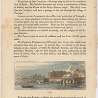
Portugal
Baynes, Thomas S.; Smith, William Robertson
Cartografia
Portugal : Nº 4
Cartografia
Portugal : West Coast : entrance of the River Tagus with the Harbour of Lisbon (Lisboa) : compiled from various Portuguese Government surveys to 1879 : with corrections to 1945
Richards, G. H.
Cartografia
Portugal's Magnificent Roads now enable the travellers to make all excursions by car : Map of the international and other first-class roads connecting the principal tourist resorts, as ordered by the Commission of Tourism of the AUTOMOVEL CLUB DE PORTUGAL, Largo do Calhariz 29, Lisbon
Automóvel Club de Portugal. Comissão de turismo
Cartografia
Portuguese Islands in the Atlantic Ocean
Gravuras e Desenhos
Se Velha, or old Cathedral : Coimbra
Holland, T.
Cartografia
Spain & Portugal
Harvey, William, 1796-1866
Cartografia
Spain : North Coast : Foz to Camariñas : from the spanish government charts of 1915 to 1920 : with additions and corrections to 1935
Edgell, J. A.
Cartografia
Spain and Portugal
Cartografia
Spain and Portugal
Cartografia
Steel's new and correct chart of the coasts of Spain and Portugal : including plans at the principal harbours on an enlarged scale
Steel & Co.
Cartografia
West Coast of Africa : Sheet I : Cape Spartel to Mazighan
Arlett, William
Cartografia
West Coast of Africa : Sheet II : Azamor to Sta. Cruz
Arlett, William
Cartografia
West Coast of Africa : Sheet III : Sta. Cruz to Cape Bojador
Arlett, William
Cartografia
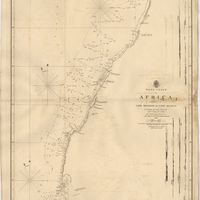
West Coast of Africa : Sheet IV : Cape Bojador to Cape Blanco
Vidal, Alexander Thomas Emeric; Roussin, Albion René, Baron de
Cartografia
West Coast of Africa : Sheet IX : Sherboro Island to Cape Mesurada
Bedford, George Augustus; Vidal, Alexander Thomas Emeric
Cartografia
West Coast of Africa : Sheet V : Cape Blanco to Cape Verde
Roussin, Albion René, Baron de
Cartografia
West Coast of Africa : Sheet X : Cape Mesurada to Cape Palmas
Bedford, George Augustus; Vidal, Alexander Thomas Emeric
Cartografia
West Coast of Africa : Sheet XI : Cape Palmas to Grand Lahou
Vidal, Alexander Thomas Emeric; Bedford, George Augustus
Cartografia
West Coast of Africa : Sheet XII : Grand Lahou to Cape Three Points
Vidal, Alexander Thomas Emeric; Bedford, George Augustus
Cartografia
West Coast of Africa : Sheet XIII : Cape Three Points to Barracoe
Vidal, Alexander Thomas Emeric; Bedford, George Augustus
Cartografia
West Coast of Africa : Sheet XIV : Barracoe to Cape St. Paul
Vidal, Alexander Thomas Emeric; Bedford, George Augustus
Cartografia
West Coast of Africa : Sheet XVII : Cape Formosa to Fernando Po
Owen, William Fitzwilliam; Bedford, George Augustus; Vidal, Alexander Thomas Emeric; Allen, William
Cartografia
West Coast of Africa : Sheet XVIII : Fernando Po to Cape Lopez
Owen, William Fitzwilliam; Bedford, George Augustus; Vidal, Alexander Thomas Emeric
Cartografia
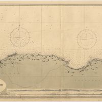
West coast of Spain and Portugal : Cape Finisterre to Cape St. Vincent : compiled from the latest information in the Hidrographic Office to 1881
Richards, George Henry
Cartografia
West coasts of Spain and Portugal : Cabo Villanno to Oporto : from the spanish and portuguese government charts to 1916 : with corrections and additions to 1921
Learmonth, Frederick C.