Os cookies.
Este site utiliza cookies para lhe proporcionar uma melhor experiência de utilização.
OK, ACEITO
Biblioteca Geral Digital
Sobre
Itens da coleção
Refinar a pesquisa
Tipo
Cartografia
23
Autor
Owen, William Fitzwilliam
6
Walker, J. & C.
5
Elliott, Wm, Capt.
3
Neele, Samuel John
3
Arrowsmith, Aaron
2
Ver mais
Data
1830
1828
1827
1810
1808
Ver mais
Local de publicação
Londres
Assunto
Mapa
13
Portugal
10
Carta náutica
6
África
5
Oceano Atlântico
3
Ver mais
Idioma
Inglês
22
Português
1
PT
EN
PT
EN
Coleção digital
Biblioteca Geral Digital
Sobre
Itens da coleção
Nesta coleção
Pesquisa avançada
Refinar a pesquisa
Limpar
Tipo
Cartografia
23
Autor
Owen, William Fitzwilliam
6
Walker, J. & C.
5
Elliott, Wm, Capt.
3
Neele, Samuel John
3
Arrowsmith, Aaron
2
Ver mais
Data
1830
1828
1827
1810
1808
Ver mais
Local de publicação
Londres
Assunto
Mapa
13
Portugal
10
Carta náutica
6
África
5
Oceano Atlântico
3
Ver mais
Idioma
Inglês
22
Português
1
Itens
23
Ver como
Grelha
Lista
Galeria
Ordenar por
Título
Título (descendente)
Data (de publicação)
Data (descendente)
Limite por página
50
100
250
Cartografia
Africa : Sheet II : from the River Gambia to cape Lopez and Annabona including the Bight of Biafra
De Mayne, Anthony; Owen, William Fitzwilliam; Vidal, Alexander Thomas Emeric
Cartografia
Africa : Sheet III : from Annabona to Hollams Island in Latde. 24º 36' S
Owen, William Fitzwilliam
Cartografia
Africa : Sheet IV : from Hollams Island to Cape Corrientes including the Cape of Good Hope
Owen, William Fitzwilliam
Cartografia
Africa : Sheet V : from Cape Corrientes to Juba Islands including Madagascar, Comoro, Zanzibar, Ids. & c.
Owen, William Fitzwilliam
Cartografia
Africa : Sheet VI : from the Juba Islands to Muscat : with the Entrance to the Red Sea
Owen, William Fitzwilliam
Cartografia
Chart of the Island of St. Michael
Read, W. Harding
Cartografia
Madrid
Society for the Diffusion of Useful Knowledge
Cartografia
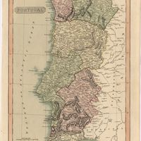
Map of Portugal
Arrowsmith, Aaron
Cartografia
A Military sketch of the country between Lisbon and Vimiero occupied by the British Army under the command of Lieutenant General Viscount Wellington
Cartografia
A new map of Spain and Portugal : exhibiting the chains of mountains with their passes, the principal & cross roads, with other details requisite for the intelligence of Military Operations
Nantiat, Jasper
Cartografia
A new map of Spain and Portugal : exhibiting the chains of mountains with their passes, the principal & cross roads, with other details requisite for the intelligence of Military Operations
Nantiat, Jasper
Cartografia
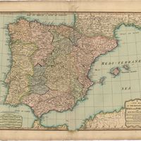
A new map of the kingdoms of Spain and Portugal with their principals divisions.
Cartografia
A new military map of Portugal : the roads from the Carta Militar published by the french in Lisbon : the rivers and mountains from the last Authorities
Elliott, Wm, Capt.
Cartografia
A new military map of Portugal : the roads from the Carta Militar published by the french in Lisbon : the rivers and mountains from the last Authorities
Elliott, Wm, Capt.
Cartografia
A new military map of Portugal : the roads from the Carta militar published by the french in Lisbon, the rivers and montains, from the best authorities
Elliott, Wm, Capt.
Cartografia
Portugal
Arrowsmith, Aaron
Cartografia
Portugal
Cartografia
Portugal
Pinnock, William
Cartografia
Portugal
Cartografia
Portugal including Algarve
Tofinõ de San Miguel, Vicente; López de Vargas Machuca, Tomás
Cartografia
Spain and Portugal
Cartografia
A topographical chart of the entrance of the river Tagus, describing the coast from Cape Roca to Sacavem ; with the harbour and environs of Lisbon. The nautical part is from a survey taken in 1806 by W. Chapman, Master of the Royal Navy; and approved by the Chart Committee of the Admiralty. The interior and line of the coast are drawn from survays made by officers of the Quarter Master General's Department
Chapman, William
Cartografia
The West Coast of Africa : Sheet XVII from Banda Point to St. Paul de Loanda including the Congo
Owen, William Fitzwilliam; Vidal, Alexander Thomas Emeric