Os cookies.
Este site utiliza cookies para lhe proporcionar uma melhor experiência de utilização.
OK, ACEITO
Biblioteca Geral Digital
Sobre
Itens da coleção
Refinar a pesquisa
Tipo
Cartografia
17
Autor
Washington, Capitão
4
Wharton, W. J. L.
3
Edgell, J. A.
2
Richards, G. H.
2
Automóvel Club de Portugal. Comissão de turismo
1
Ver mais
Data
1950
1935
1920
1910
1904
Ver mais
Local de publicação
Londres
16
Lisboa
1
Assunto
Mapa
13
França
6
Mar Mediterrâneo
6
Costa Ocidental
5
Argélia
3
Ver mais
Idioma
Inglês
PT
EN
PT
EN
Coleção digital
Biblioteca Geral Digital
Sobre
Itens da coleção
Nesta coleção
Pesquisa avançada
Refinar a pesquisa
Limpar
Tipo
Cartografia
17
Autor
Washington, Capitão
4
Wharton, W. J. L.
3
Edgell, J. A.
2
Richards, G. H.
2
Automóvel Club de Portugal. Comissão de turismo
1
Ver mais
Data
1950
1935
1920
1910
1904
Ver mais
Local de publicação
Londres
16
Lisboa
1
Assunto
Mapa
13
França
6
Mar Mediterrâneo
6
Costa Ocidental
5
Argélia
3
Ver mais
Idioma
Inglês
Itens
17
Ver como
Grelha
Lista
Galeria
Ordenar por
Título
Título (descendente)
Data (de publicação)
Data (descendente)
Limite por página
50
100
250
Cartografia
France : West Coast : La Gironde Royan to Bordeaux : from the french government chart of 1914 : with additions and corrections to 1954
Day, Archibald
Cartografia
France North Coast : Sheet VIII : Ushant to Plateau des Roches Douvres : from the pilote français 1823 : with additions and corrections to 1911
Wharton, W. J. L.
Cartografia
France West Coast Sheet IV : Les Sables d'Olonne to Bourgneuf : from the Pilote Francais with corrections from French Government Charts to 1924
Washington, Capitão
Cartografia
France West Coast Sheet V : Bourgneuf to I. de Groix : from the Pilote Francais with corrections from French Government Charts to 1949
Washington, Capitão
Cartografia
France West Coast Sheet VI : I. de Groix to Raz de Sein : from the French Government Charts of 1828 : with corrections to 1933
Washington, Capitão
Cartografia
France-North West Coast : Sheet VII : Raz de Sein to Goulven including Brest and Ushant : from French Government Charts to 1919
Washington, Capitão
Cartografia
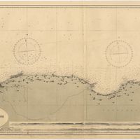
Mediterranean : Africa : C. Tres Forcas to C. Ivi : surveyed by Captain E. Mouchez of the french Navy 1870-73
Wharton, W. J. L.
Cartografia
Mediterranean : Algeria : Algiers to C. Bougaroni : surveyed by Captain E. Mouchez of the french Navy 1867-9 : with corrections from the french gouvernment charts 1925-1926
Wharton, W. J. L.
Cartografia
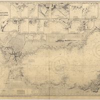
Mediterranean : Algeria : Tunis : C. Bougaroni to Fratelli Rocks including Galita Channel
Richards, G. H.
Cartografia
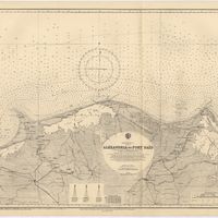
Mediterranean Sea : Egypt : Alexandria to Port Saïd
Reyne, F. A.; Hill, S. A. G.; Douglas, H. P.
Cartografia
Mediterranean Sea : Europe Gibraltar to Alicante : Africa Cape Spartel to Cape Ferrat : from spanish and french government charts to 1877
Evans, F. J.
Cartografia
Mediterranean Sea : Libya : Ras Ashdir to Sirte : from the italian Gouvernment charts of 1931-32
Edgell, J. A.
Cartografia
Portugal : West Coast : entrance of the River Tagus with the Harbour of Lisbon (Lisboa) : compiled from various Portuguese Government surveys to 1879 : with corrections to 1945
Richards, G. H.
Cartografia
Portugal's Magnificent Roads now enable the travellers to make all excursions by car : Map of the international and other first-class roads connecting the principal tourist resorts, as ordered by the Commission of Tourism of the AUTOMOVEL CLUB DE PORTUGAL, Largo do Calhariz 29, Lisbon
Automóvel Club de Portugal. Comissão de turismo
Cartografia
Spain : North Coast : Foz to Camariñas : from the spanish government charts of 1915 to 1920 : with additions and corrections to 1935
Edgell, J. A.
Cartografia
West coast of Spain and Portugal : Cape Finisterre to Cape St. Vincent : compiled from the latest information in the Hidrographic Office to 1881
Richards, George Henry
Cartografia
West coasts of Spain and Portugal : Cabo Villanno to Oporto : from the spanish and portuguese government charts to 1916 : with corrections and additions to 1921
Learmonth, Frederick C.