Os cookies.
Este site utiliza cookies para lhe proporcionar uma melhor experiência de utilização.
OK, ACEITO
Biblioteca Geral Digital
Sobre
Itens da coleção
Refinar a pesquisa
Tipo
Cartografia
14
Gravuras e Desenhos
3
Livro Moderno
1
Autor
Owen, William Fitzwilliam
4
Walker, J. & C.
3
Cary, John
1
Faden, William
1
Froggett, John
1
Ver mais
Data
1827
1801
1800
1797
1794
Ver mais
Local de publicação
Londres
11
Edimburgo
1
Liverpool
1
London
1
Assunto
Mapa
7
Portugal
6
África
4
Carta náutica
3
Oceano Atlântico
3
Ver mais
Idioma
Inglês
PT
EN
PT
EN
Coleção digital
Biblioteca Geral Digital
Sobre
Itens da coleção
Nesta coleção
Pesquisa avançada
Refinar a pesquisa
Limpar
Tipo
Cartografia
14
Gravuras e Desenhos
3
Livro Moderno
1
Autor
Owen, William Fitzwilliam
4
Walker, J. & C.
3
Cary, John
1
Faden, William
1
Froggett, John
1
Ver mais
Data
1827
1801
1800
1797
1794
Ver mais
Local de publicação
Londres
11
Edimburgo
1
Liverpool
1
London
1
Assunto
Mapa
7
Portugal
6
África
4
Carta náutica
3
Oceano Atlântico
3
Ver mais
Idioma
Inglês
Itens
18
Ver como
Grelha
Lista
Galeria
Ordenar por
Título
Título (descendente)
Data (de publicação)
Data (descendente)
Limite por página
50
100
250
Cartografia
Africa : Sheet III : from Annabona to Hollams Island in Latde. 24º 36' S
Owen, William Fitzwilliam
Cartografia
Africa : Sheet IV : from Hollams Island to Cape Corrientes including the Cape of Good Hope
Owen, William Fitzwilliam
Cartografia
Africa : Sheet VI : from the Juba Islands to Muscat : with the Entrance to the Red Sea
Owen, William Fitzwilliam
Cartografia
Atlantic islands
Thomson, John
Cartografia
Chart of the Açores (Hawks) Islands, called also Flemish and Western Islands.
Cartografia
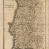
Chorographical map of the kingdom of Portugal divided into its grand provincies = Mappa corografico do Reino de Portugal
Faden, William
Gravuras e Desenhos
Coimbra : Fig. 197
Gravuras e Desenhos
Coimbra in Portugal
Holland, James
Cartografia
Europe
The Edinburgh Geographical Institute; John Bartholomew & Co.
Cartografia
The Kingdoms of Portugal and Algarve from Zannonïs Map
Rizzi-Zannoni,Giovanni Antonio
Cartografia
A new map of the Kingdom of Portugal divided into its provinces
Cartografia
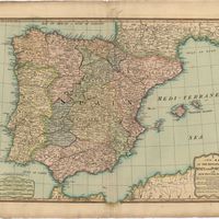
A new map of the kingdoms of Spain and Portugal with their principals divisions.
Cartografia
Portugal
Cartografia
Portugal including Algarve
Tofinõ de San Miguel, Vicente; López de Vargas Machuca, Tomás
Cartografia
The present seat of war in Portugal : with the positions of the French and allied armies.
Gravuras e Desenhos
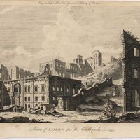
Ruins of Lisbon after the Earthquake in 1755 : engraved for Barlows General History of Europe
Livro Moderno
Views in Egypt, from the original drawings in the possession of Sir Robert Ainslie, taken during his embassy to Constantinople by Luigi Mayer
Mayer, Luigi
Cartografia
The West Coast of Africa : Sheet XVII from Banda Point to St. Paul de Loanda including the Congo
Owen, William Fitzwilliam; Vidal, Alexander Thomas Emeric