Os cookies.
Este site utiliza cookies para lhe proporcionar uma melhor experiência de utilização.
OK, ACEITO
Biblioteca Geral Digital
Sobre
Itens da coleção
Refinar a pesquisa
Tipo
Cartografia
15
Livro Antigo
2
Gravuras e Desenhos
2
Autor
Spofforth, Robert
2
Wells, Edward
2
Adams, George
1
Alagna, J. Giacomo
1
Bowen, Emanuel
1
Ver mais
Data
1756
1750
1747
1732
1700
Ver mais
Local de publicação
Londres
Assunto
Iconografia
3
Lisboa
3
Peninsula Ibérica
3
Portugal
3
Açores
2
Ver mais
Idioma
Inglês
17
Português
2
PT
EN
PT
EN
Coleção digital
Biblioteca Geral Digital
Sobre
Itens da coleção
Nesta coleção
Pesquisa avançada
Refinar a pesquisa
Limpar
Tipo
Cartografia
15
Livro Antigo
2
Gravuras e Desenhos
2
Autor
Spofforth, Robert
2
Wells, Edward
2
Adams, George
1
Alagna, J. Giacomo
1
Bowen, Emanuel
1
Ver mais
Data
1756
1750
1747
1732
1700
Ver mais
Local de publicação
Londres
Assunto
Iconografia
3
Lisboa
3
Peninsula Ibérica
3
Portugal
3
Açores
2
Ver mais
Idioma
Inglês
17
Português
2
Itens
19
Ver como
Grelha
Lista
Galeria
Ordenar por
Título
Título (descendente)
Data (de publicação)
Data (descendente)
Limite por página
50
100
250
Cartografia
Azores
Torfino de San Miguel, Vincente; Claret de Fleurieu, Charles Pierre
Cartografia
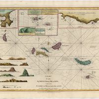
A Chart of the Açores (Hawks) Islands, called also Flemish and Western Islands from Mr. D'Anviille with several additions.
Cartografia
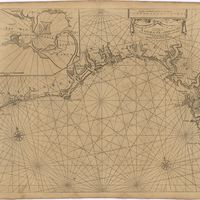
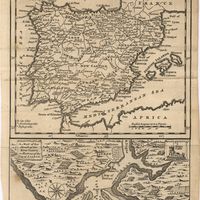
A chart of the sea coasts of Algrave [sic] and Andalusia between cape St. Vincent and the strait of Gibralter and c. Spartel
Cartografia
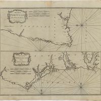
The Coast of Portugal from River de Sinis to Siluis ; The coast of Andalousie from Siluis to Pallos.
Cartografia
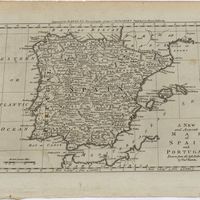
A correct map of Spain & Portugal : according to the newest observations and discoveries comunicated to the Royal Society at London and the Royal Academy at Paris is humbly dedicated to the Right Honorable Iohn Ld. Somers Baron of Evesham
Livro Antigo
Do uso, e abuso das minhas Agoas de Inglaterra, ou Directorio, e instruccam, para se saber seguramente, quando se deve, ou naõ, usar dellas, assim nas enfermedidades agudas; como em algumas chronicas; e em casos propriamente de cirurgia
Sarmento, Jacob de Castro
Cartografia
Island of Madera ; The Dragon Tree
Cartografia
A Map of the River Tale to Lisbon Done from a New Survey
Livro Antigo
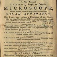
Micrographia illustrata, or, The knowledge of the microscope explain'd together with an account of a New Invented Universal, single or double, Microscope, either of which is capable of being applied to an Improv'd Solar Apparatus. This Treatise contains a Description of the Nature, Uses, and Magnifysing Powers of Microscopes in general; together with full Directions how to prepare, apply, and examine, as well as preserve, all Sorts of minute Objects also an account of The principal Microcopical Discoveries, that have hirherto been mentioned by the most celebrated Authors, togeher with a great Variety of new Experiments and Observations. The whole being, as it were, A Natural History of a Multitude of Aerial, Terrestrial, and Aquatick Animals, Seeds, Plants, Etc. To which is added, A Translation of Mr. Joblott's Observations on the Animalcula, that are found in many different Sorts of Infusions and a very particular Account of the surprising Phaenomenon, The Fresh Water Polype, translated from the French Treatise of Mr. Trembley. This Work is compiled for the Assistance of those, who are desirous of surveyng the extensive Beauties of the minute Creation and is illustreted with 65 Copper-plates, curiously engrav'd, wich contain above 560 Pictures of Microscopic Objets
Adams, George; Trembley, Abraham
Cartografia
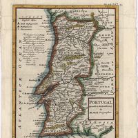
A new and accurate map of Portugal : composed from the latest improvem.ts and adjusted by the most authentic astron. observats.
Cartografia
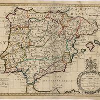
A new and accurate map of Spain and Portugal : drawn from the best Authorities
Bowen, Thomas
Cartografia
A new map of Iberia Europaea alias Celtiberia, or Ancient Spain : shewing its principal divisions, cheif cities, townes, rivers, mountains & c[?]. Dedicated to His Highness William Duke of Gloucester
Wells, Edward
Cartografia
A new map of present Spain & Portugal : shewing their principal divisions, cheif cities, townes, rivers, mountains & c. : Dedicated to His Highness William Duke of Gloucester
Wells, Edward
Cartografia
A plan of the city of Lisbon with the Harbour, Forts, Depth of Water and Country adjacent : for the Lond. Mag.
Cartografia
Portugal : agreeable to modern history
Moll, Herman
Gravuras e Desenhos
Ruins of Lisbon after the Earth-Quake on the 1st. Nov.br 1755 : The Opera House
Cartografia
Spain and Portugal
Cartografia
Spain and Portugal. A map of the mouth of the River Tagus or harbour of the city of Lisbon
Gravuras e Desenhos
A view of the Palace of the King of Portugal at Lisbone = Vüe de Palais Roi de Portugale à Lisbon